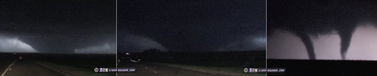
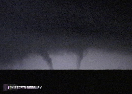
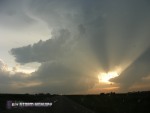
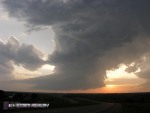
Storm Highway by Dan Robinson
Weather, photography and the open roadClick for an important message
Storm Highway by Dan RobinsonClick for an important message

Massive F5 tornado destroys Greensburg, Kansas: Strongest tornado in 8 years wipes out entire town, kills at least 12
May 4, 2007

ABOVE: The Greensburg, Kansas tornado is illuminated by lightning.

EXPEDITION VIDEO: Greensburg, Kansas tornadoes and damage: Watch Video

Click any thumbnail on this page to view a larger version.

By DAN ROBINSON
Editor/Photographer
Important Message 30 Years of Storm Chasing & Photography Dan's YouTube Video Channel Dan's Twitter feed Dan's RSS/XML feed

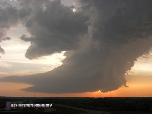
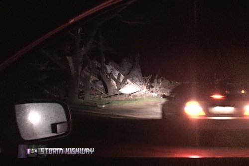
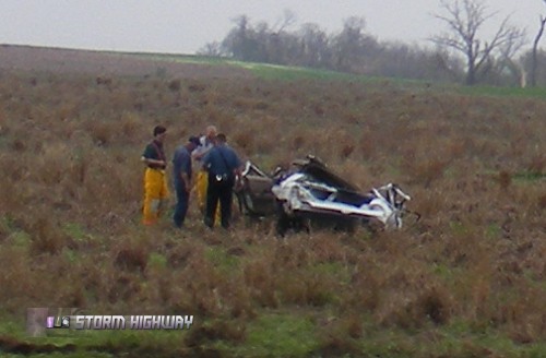
GREENSBURG, KS - A large, violent tornado devastated parts of southwest Kansas on Friday, May 4, 2007. The tornado was rated EF5 on the (enhanced) Fujita scale, the first F5 rating in almost exactly 8 years. Literally the entire town of Greensburg, Kansas was obliterated by the massive tornado, which struck after dark on Friday evening. While I feel priveleged to have witnessed an F5 - the strongest of tornadoes and a rarity in storm chasing (and in tornado history for that matter), it is hard for me to call this chase a success. The tragedy of the lives lost and property destroyed puts a damper on this event for me, and precludes any celebration of the intercept. The following is a account of the day's chase.

I began the day in Pratt, Kansas with Fabian Guerra and Craig Maire. We lingered around the Dodge City area before moving east as the dryline began to mix eastward. I was watching two areas of interest - an area of surface convergence and cumulus west of Wichita, and the area south of the dryline bulge in northwestern Oklahoma. As the afternoon wore on, no signs of immediate storm formation were evident. Finally the cumulus near Wichita began bubbling up, so we started heading in that direction - passing through the town of Greensburg on the way. I was keeping a cautious eye on our secondary area to the southwest.

The development near Wichita soon lost its promise, and about the same time we noted strong cumulus formation in the northeast Texas panhandle. A small blip showed up on radar near Canadian, TX, and I knew it was going to put on a show. It quickly grew into a massive supercell with confirmed tornadoes. We immediately began the long trek to intercept. At some point, I got separated from Fabian and Craig and was solo the rest of the way.

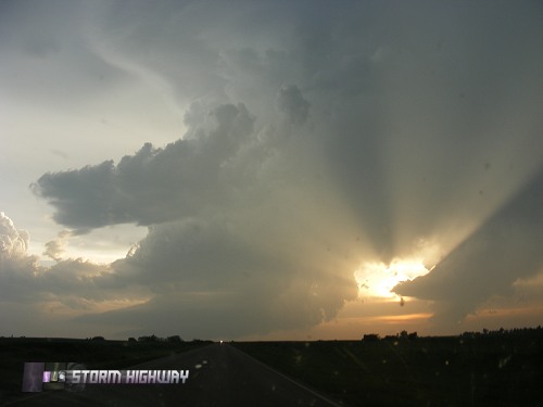
The tornadic storm soon split and sent a cluster of weak cells northward. I ignored these at first, focusing on getting to the main southern cell. I caught up to the storm at Mooreland, Oklahoma just before sunset, where it took on an LP structure. By this time, the storm was long done producing tornadoes, but the combination of sunset and clear skies surrounding it made for an impressive sight.

At this time, I noticed the cells to the north were intensifying as the Mooreland/Woodward storm weakened. Even though it was now getting dark, I shifted my focus to this development and began heading north out of Mooreland.

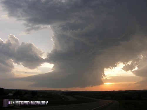
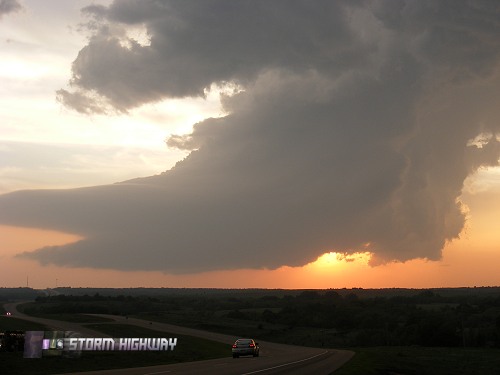
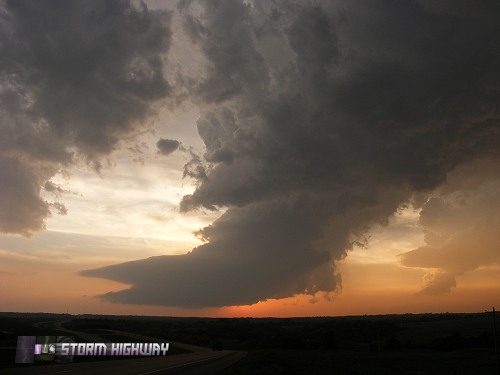
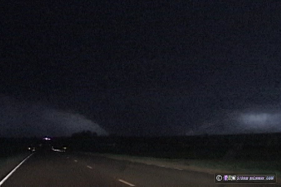
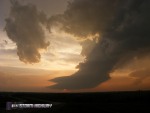
As I closed the gap on the storm, it was growing into one of the largest supercells I'd ever seen on my WxWorx radar display. I had a good visual on it the entire way north, and it filled the sky in front of me with constant lightning. As I got closer, well-defined supercell structure was evident - a bell-shaped updraft, tapered tail cloud and inflow bands. Rotation markers on WxWorx began appearing and strengthening.

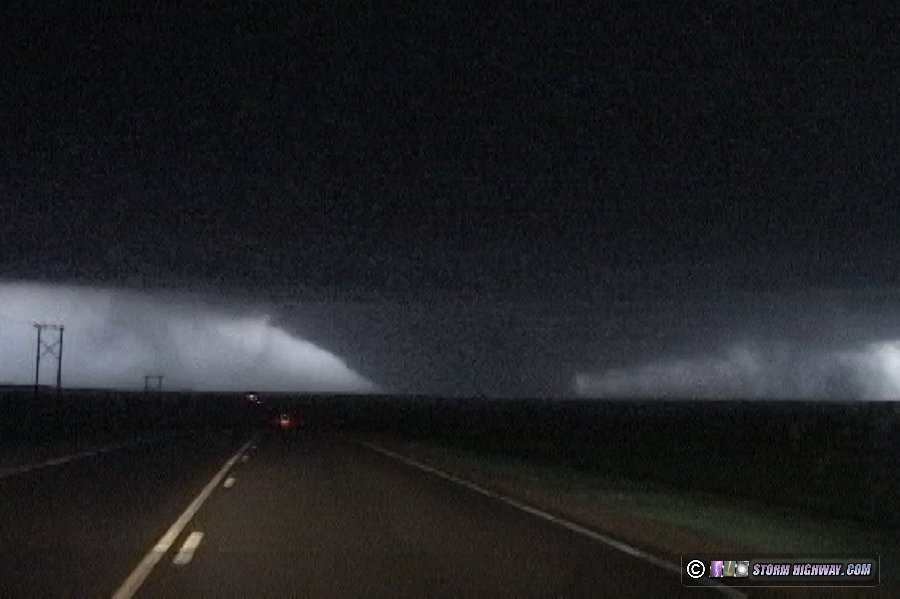
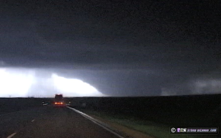
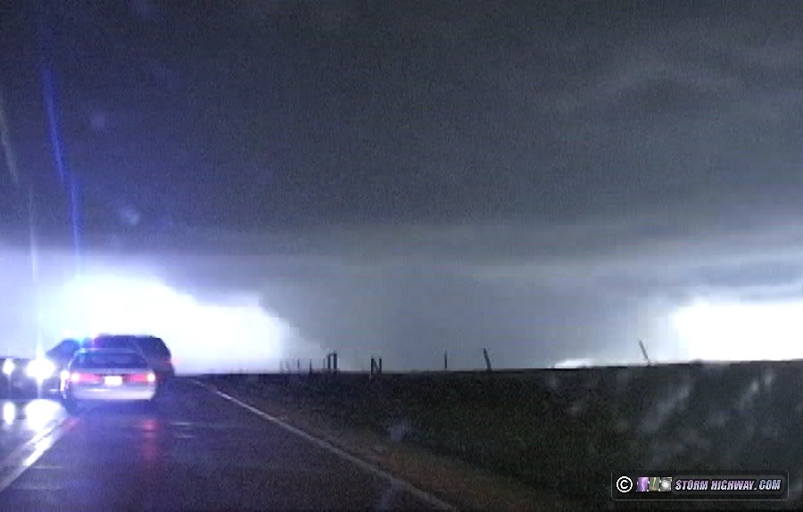
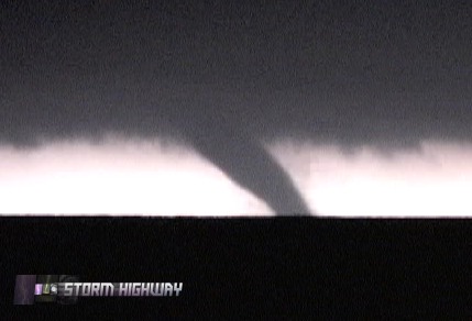
I was about 15 miles south of the storm, passing through Coldwater on Highway 183, when Fabian called. He and Craig had arrived on the storm a few minutes before me, and were already watching a large wedge tornado in progress. Before that point I was not sure what I was going to find once the storm's base came into view, though I was nearly certain a tornado was in progress based on the storm's radar presentation. I was not surprised to hear about a wedge, as WxWorx showed 161mph shear markers on the storm - the highest I'd seen on the data display yet.

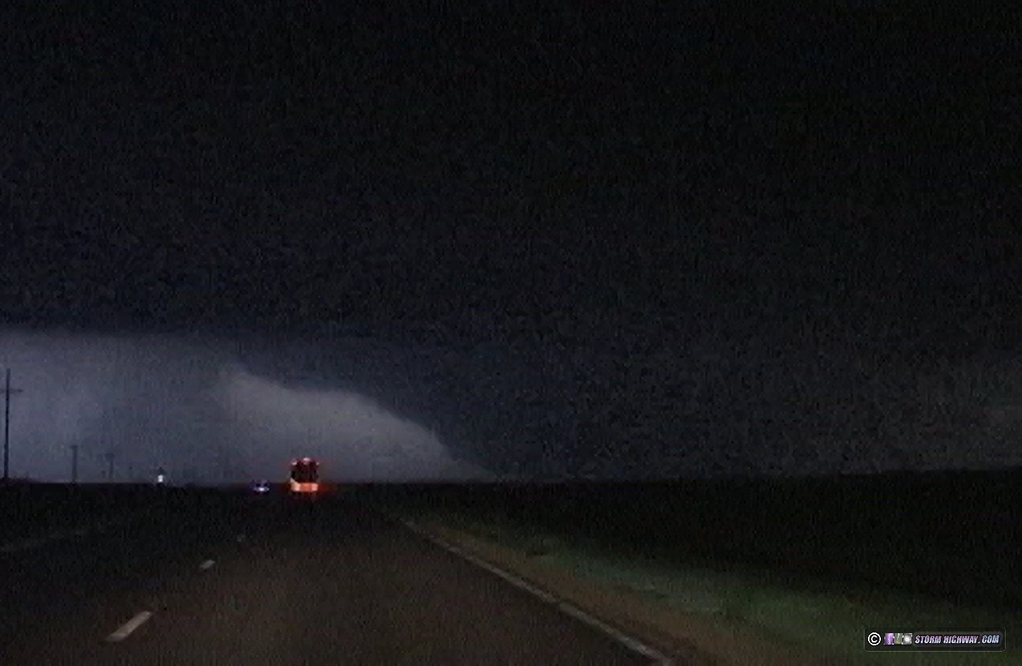
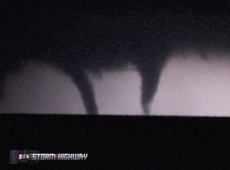
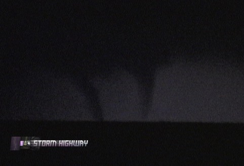
Minutes later as I drove north on 183, the tornado became visible - and I could hardly believe what I was seeing.

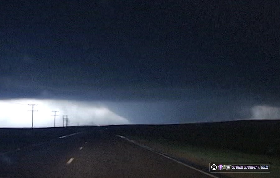
This was not just a wedge tornado - it was an absolutely huge wedge. All I could think about was Greensburg up ahead and how similar the situation was to Hallam, Nebraska on May 22, 2004 - a massive tornado heading straight for a town.

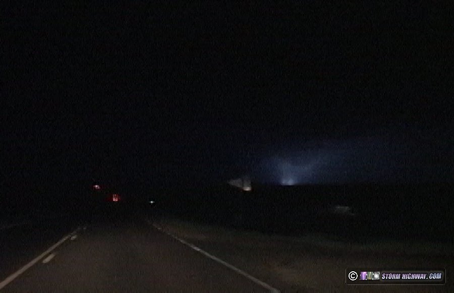
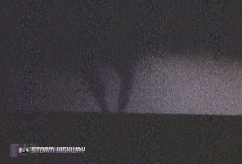
I kept driving toward the tornado as lightning kept it in sight.

A power flash appeared on the right side of the funnel.

As I neared Greensburg, I began encountering damage where the tornado began tracking across and along highway 183. The sawmill-like smell of shredded trees and wood filled the air.

A loud hissing sound and the smell of natural gas ahead signaled to me that a gas line was leaking. From the volume of the hissing sound, I expected to pass it any second. But as I kept going north, it only got slowly louder. As I approached the source, the hiss turned into a whistling roar before I realized what it was coming from - a large gas pipeline, around 16-18 inches or more in diameter. A natural gas pumping station next to the road had been destroyed, with at least five major leaks screaming loudly and propelling large amounts of gas into the air. Some of the leaks were jetting out into the road. It was the sound and smell of these leaks combined with the mangled metal of the pumping station that started driving home the reality of how strong this tornado was.

The drive north became more harrowing as I progressed. Power lines were lying everywhere and cows were wandering on the road, set loose by destroyed fencing.

By this time, I had re-joined Fabian and Craig. The gravity of the disaster became more and more apparent as the chaos of destruction increased with every minute toward Greensburg. We stopped briefly where a group of storm chasers including Dick McGowan were assisting a man who has just escaped the rubble of his house.

Continuing north and maneuvering around debris, I looked over to the right to see a new tornado fully condensed to our northeast. I immediately stopped and started filming.

The next lightning flash revealed another tornado had already formed within seconds, right next to the first. The tornadoes either rotated around each other or merged, as lightning flashes revealed them getting closer together.

Progressing north, our path was finally blocked by toppled power poles a little over a mile south of Greensburg. This ended the chase for us, and we turned around and headed back south. We ended the day in Pratt, where the scale of the disaster was evident. All night and into the morning, the sound of ambulance sirens in Pratt and highway crews blocking the road west to Greensburg were signals that we had just witnessed a tragedy.

Our next target for Saturday took us through a damage path from Friday's tornado, near St. John. Damage was noted for nearly two continuous miles. Amazingly, Saturday we would witness more tornadoes touching down within the damage swaths of Friday's tornadoes - the same locations being hit twice in 24 hours.

Prayers and thoughts go out to all affected by this outbreak.

These are good pic!
- Posted by Megan
This is a grate website but I would love it if it had live footage
- Posted by amy from oakland
NIce photos keep up the good work.
- Posted by Brandon West from elizabethtown
awsome pictures
- Posted by David Atwood from school
It was an EF 5 (on Enhance Fujita Scale) which would've been a high F3 or F4 on the old scale. We started using this "enhanced" fujita scale in Feb. 2007. and it's confused media sources (saying it's the most powerful in 8 years). Nice pictures though, my mouth is watering for the coming season
- Posted by Joe from Lincoln, NE
The EF scale is considered interchangeable with the old F-scale ratings. Only the estimated wind speeds for each category were adjusted on the EF scale. As far as damage intensity, the old and new scales are the same - Greensburg would indeed have been an F5 on the old scale. Greg Stumpf, who helped develop the new EF scale, commented on this subject in a StormTrack thread (link here).
- Posted by Dan R from Charleston, WV
They estimate the wind speeds based on the damage observed. On the new scale tornados have a greater chance of achieving the 5 rating because they lowered the winds speeds for each category. I think that's what Joe meant. Greensburgh's windspeeds were estimated 205mph, which would've been high high F3 on the old scale.
- Posted by Earl T. from Oklahoma City
The change from the F scale to the EF scale did lower Fujita's original wind estimates for each category. However, this simply means that it has been found that slower wind speeds than previously thought are capable of F5/F4 damage. In other words, F5 damage and EF5 damage are the same, and F4 and EF4 are the same. Tornadoes are rated solely by the damage they cause, the associated wind estimates for each damage category are just that - only estimates. The slower wind speeds associated with the EF scale reflect that it is now known that you don't actually need winds greater than 261 mph to create F5 damage, for instance. F5 damage can occur with winds as low as 205 mph. The new wind estimates mean that tornadoes in the past that were rated F5 didn't necessarily reach wind speeds of 261 mph as previously thought. They were still F5s nonetheless - their damage reached the same category regardless of whether the winds were 205mph or 261mph. 261 mph was only an estimate that Fujita assigned to his original scale. So an EF5 today is not weaker than an F5 of the past, nor is it now easier for a tornado to reach EF5 than F5. They both must produce the same degree of damage to attain the rating - something that the Greensburg tornado certainly did.
- Posted by Dan R. from Charleston, WV
thats scary man just looken at the pics gives me the chills
- Posted by tina davis from summerville
i see worse F4 damage than this. in true f5 damage only the basements of houses would be left, grass be GONE, straw penetrates at those windspeeds
- Posted by jorge from sna antonio
Wait a minute. If windspeeds were only 205 miles per hour, how is that the "most powerful" since the Moore tornado?
- Posted by George from Iowa
It's not. New scale. Media sources are confused since it got the '5' rating. And yes, on the old scale, 205mph would only be an F3. From a climatological standpoint, meteorologists are going to be ripping out their hair keeping track of records now that they installed this new scale and threw out the old one. They should keep it around as a reference such as for this one: "EF5 (F3)". By changing the rules in the middle of the game they've skewed climatology records.
- Posted by Kirk from Tulsa, OK
Remember that the tornado is rated by the damage it causes, not by its estimated wind speeds. This is where most of the confusion lies. The wind speeds are only estimates based on the observed damage. The damage criteria for EF5 and F5 are the same - the Greensburg tornado received an EF5 rating because the damage was of F5 intensity. The damage photos show that Greensburg was no F3. It may not have been as strong as Moore, but plenty of damage reached F5 criteria. Unless the Doppler-on-Wheels units are there, tornado wind speeds don't get measured (Moore was the only F5 to be measured by a DOW). The F5s of the past likely did not need to reach 261mph to produce the damage they did, this is why the wind speed estimates for F5 were lowered. Refer to Greg Stumpf's comments here (Stumpf was one of the scientists who helped develop the EF scale).
- Posted by Dan R. from Charleston, WV
That really does show the sheer destruction one of those can do. Realistically, I agree with you in the respect of it being both a win for science and a very very very big lose for society. The damage was phenomenal. I still can't believe it. Mind you i've heard a lot about tornado's and would love to take some photo's myself one day and do storm chasing. Its a career that does interest me. Hope all goes well for you, and hopefully, Next time we (the society at large,whether it be USA or abroad) don't have to see a "beautiful tornado" inflicting so much damage.
- Posted by Timothy Cole from Australia
I am sorry if I happened to spark a scurmish on here with bringing up the EF scale... WOW. On the new scale have they also changed how strong winds have to be to toss certain vehicles? If that's the case, would the Hallam F4 tornado be rated different taking into account the damage it did to Norris school, multiple houses literally pushed off their foundations and that line of freight cars that were tossed (found laying in the shape of a question mark)?
- Posted by Joe H. from Lincoln, NE
Wind estimates aren't used in the rating process - only the observed damage is. Wind estimates are simply *estimated* values assigned to each category in the scale. For all intents and purposes, the EF scale and the F scale are the same. That is, the damage severity needed to obtain a particular rating is the same today as it was ten years ago. As Stumpf puts it, EF5=F5, EF4=F4, and so on. A tornado today would get the same rating on the new scale as it would have on the old one, because it's the *damage* being used to assign the rating, not the estimated wind speeds (which are impossible to measure without a Doppler on Wheels being on every tornado). The new EF scale made two changes - one, the wind estimates for each category were revised (which doesn't affect the actual rating process), and two, the damage indicator system was added to allow new objects to be used in rating damage. For example, the EF scale now allows tree damage to be considered in higher-end tornado ratings. This was not the case in the old F-scale, so a tornado that hit nothing but open country and trees could not be rated higher than F0-F1 on the old scale. The new scale simply takes into account much finer details in tornado damage paths than the old scale did.
- Posted by Dan Robinson from Charleston, WV
I understand that much... but it's just that from what I've gathered for example, is that pictures of F4 damage wouldn't completely collapse a house but pictures of EF4 damage show houses completely shredded to the ground. So I was woundering if they had reconsidered the level of damage on certain structures (not just all of them)
- Posted by Joe from Lincoln, NE
Okay, I've looked into it a little more and now I'm starting to understand what they did with the new scale.
- Posted by Kirk from Tulsa, OK
Love THe Pic They are awosome
- Posted by Happyness from Woodburn Oregon
Well said, Dan R. I would also like to add that the Moore, OK tornado's winds were measured nearly 100 yds. above the ground, where it is believed that winds speeds are much higher. Also, the DOW measures wind speeds with laser beams, simply because it would be impossible for any anemometer to survive winds of such great force. Lastly, the Moore, OK of 1999 and the Jarell, TX tornado of 1997 sparked controversy among engineers on whether or not it would take winds of 300m/h or more to inflict such damage on buildings. In conclusion, they found that winds of only 200m/h would be needed to cause F5 damage.
- Posted by Brian from Monument, CO
excellent footage. :)
- Posted by john
Really useful
- Posted by Ice
Really useful
- Posted by Ice
Awesome report! The pictures really give those who haven't witnessed a tornado a real feel. Love the live footage. That's really quite rare to see a tornado at night time! Overall that was really awesome. Thanks for doing my homework!!
- Posted by Coco from New York
Awesome report! The pictures really give those who haven't witnessed a tornado a real feel. Love the live footage. That's really quite rare to see a tornado at night time! Overall that was really awesome. Thanks for doing my homework!!
- Posted by Coco from New York
Awesome report! The pictures really give those who haven't witnessed a tornado a real feel. Love the live footage. That's really quite rare to see a tornado at night time! Overall that was really awesome. Thanks for doing my homework!!
- Posted by Chloe from New York
30 Years of Storm Chasing & Photography
Important Message
Dan's YouTube Video Channel
Dan's Twitter feed
Dan's RSS/XML feed

GO: Home | Storm Expeditions | Photography | Extreme Weather Library | Stock Footage | Blog

Featured Weather Library Article:

How lightning works
Does it go up or down? A detailed description of lightning from start to finish.
More Library Articles

All content © Dan Robinson. All usage requires a paid license - please contact Dan for inquiries.

Web Site Design and Internet Marketing by CIS Internet