 Roane County Lightning: Wallback, WV, April 10, 2001 - 7:00 PM Roane County Lightning: Wallback, WV, April 10, 2001 - 7:00 PM
Only April 10, and four storm chase days already.
I was still tired after only 4 hours of sleep the night before, thanks to lightning near Ripley on Monday night. But when I saw this cell at 6:15pm, just beginning to form and spit out bright cloud-to-ground strikes just northeast of Dunbar, I couldn't resist. This storm was one of a small line of cells moving rapidly east-northeast across central West Virginia. In fact, everything was moving so fast that I had to drive all the way to Wallback, near the Roane-Clay County line along Interstate 79, to finally catch up with the storm's electrically active area.
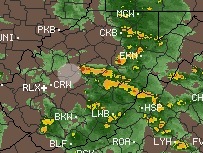
 I broke through an area of heavy rain just south of the Wallback exit, and was immediately greeted by several bright CG flashes just to the west- which prompted me to exit the Interstate and set up under the overpass facing northeast (center of circle in the radar image at right). I broke through an area of heavy rain just south of the Wallback exit, and was immediately greeted by several bright CG flashes just to the west- which prompted me to exit the Interstate and set up under the overpass facing northeast (center of circle in the radar image at right).
As I set up the 35mm camera, my new one-year-old mini-tripod decided to give out. A crack in its head finally opened up, leaving only a small sliver of plastic to hold the camera steady. I really thought that thing should have lasted longer than a year. Nonetheless, I was able to shoot several frames with the crippled tripod, and I may have caught one or two of the flashes in the videos at right.
Video: Panasonic VHS-C Palmcorder PV-L857 |