
|
|||||||||||||||||||||||||||||||||||||||||||||||||||||
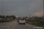
MCKITTRICK, MO - A tornadic supercell moved from near Booneville, Missouri along I-70 into the St. Louis metro, producing a violent EF4 tornado in north St. Louis and giant hail along its track. The setup for the day was a warm front draped along the I-70 corridor across Missouri. As the day progressed, a surface low moved eastward into the area, pushing the warm front slowly north as a cold front moved east. Clearing skies allowed the warm sector ahead of the low to destabilize. Above, strong southwesterly 500mb winds overspread the threat area, providing deep-layer shear. Storms were expected to fire on the cold front and potentially go tornadic in the warm sector. Storms interacting with the warm front had the highest potential for tornadoes. The ideal area for a supercell to form was north and west of Columbia, where backed winds and warm frontal interaction would maximinze the tornado potential. Consequently, I targeted I-70 in the vicinity of Columbia, leaving New Baden, IL around 3PM. Just prior to departing for the chase, a Fox 2 crew stopped by for a quick interview: VIDEO: Fox 2 interview As I drove west on I-70, I passed a major traffic backup in the eastbound lanes near Foristell due to multiple chain-reaction accidents (cause unknown, it was dry and sunny). This would have major implications for the chase, as I had originally expected I-70 to be a good way to reposition eastward for a storm that might track along the highway. Finally, convection was getting organized south of Booneville, near Sedalia. This storm was too far south of the warm front for a high tornado threat, but as the minutes ticked by it became apparent that no storm to its north would be getting established. I headed south toward Jefferson City on Highway 54 from the Fulton area to intercept the storm. I turned west on Highway Oo at Holts Summit and could already see dramatic supercell structure from the storm about 20 miles away.
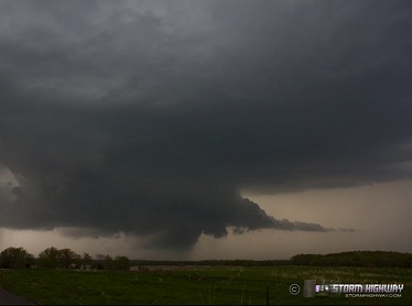
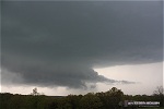
 The terrain here was hilly, and I had to drive a considerable distance to find a good view. I ended up on a dead-end gravel road past the end of Highway Oo before finding an acceptable viewing spot. Supercell structure was dramatic:
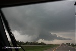
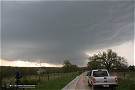
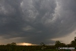   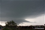 Despite the appearance, low-level cloud motion under the storm's base was weak, and it did not have any indication of producing tornadoes in the short term. I finally had to move back east to Highway 54 to keep from getting overtaken by the storm, now approaching the highway fast:
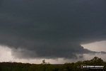
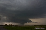
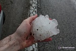
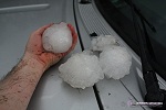
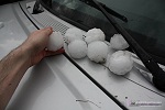
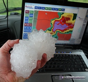
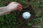
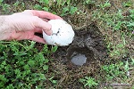
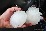
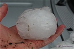
 The storm's circulation beat me across the highway by about 2 miles near New Bloomfield. A difficult decision had to be made now. I could take a curvy, winding east road here to cut over to Highway 94 and stay with the storm (which I saw several other storm chasers do), or I could go back up to I-70 and blast east ahead of the storm, then drop south to re-intercept. The problem with the Highway 94 option was that I now realized how fast the storm was moving east, and I doubted I could keep up with it safely on the wet, curvy, hilly roads. The danger with the I-70 east route was the aforementioned traffic jam, which there was no way to know whether it had been cleared or not. Fortunately, there were frontage roads along I-70 that I could use to bypass any jams. I made it back to I-70 north of Fulton and began the trek eastward, very nervous about hitting the traffic jam. Getting caught in a shut-down interstate would end the chase. I needed to get across a creek west of Williamsburg before I'd have unbroken eastbound frontage road options - if I hit traffic before then, it would be "chase over". I breathed a sigh of relief when I reached Williamsburg, exiting and taking the frontage road east from there. I still didn't know if the traffic backup was still in progress, but didn't want to find out the hard way. I now had another choice - keep blasting east on the frontage roads to near Jonesburg before turning south ahead of the storm, or making an earlier turn south at Mineola on Highway J then Highway 19 to McKittrick. I chose the earlier option, mainly due to the fact that I was already entrenched in the storm's northern flank precip and apparently not making good headway on the wet and lower-speed frontage road. I figured I needed to take my chances and intercept now, then try and keep up on Highway 94 east of McKittrick. I knew it would be a close call with the storm's core. I encountered the first hailstones as I reached Highway 19 at Big Spring. As I traveled south, it was obvious I'd lost the race with the storm. As the hail increased in size to golfballs, I slowed it down to around 30mph. There were tennis ball hailstones in the grass on the sides of the road. The falling hail was slowly letting up, so I cautiously crept southward. Finally, the hail and rain subsided as the storm rocketed away to the east. As I traveled south on 19, the hail on the side of the road increased in size. Finally I could see softballs along the road. I found a small grassy area along the road and stopped to collect and photograph some of the hailstones. Most of the hail was 2.5" (tennis ball sized), with some baseball (3") and softball (+4") sized stones scattered around. The big stones had embedded themselves in the soft ground, creating craters. Like a kid at an easter egg hunt, I searched the field, picking up the biggest hailstones I could find. I brought two armfuls back to the truck, getting my arms and shirt muddy and dirty in the process (but not caring at all about it).
 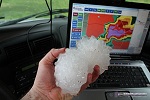   After spending about 10 minutes with the hail, I tossed the 20 or so stones I'd collected into the back of my truck (I'd wished I'd had a cooler) and continued the chase. I decided to try and get back to I-70 and atempt to catch up with the storm before it entered the St. Louis metro. It would be a long shot due to the storm's fast movement and my now being 20 miles behind. But when I turned east on Highway 94 at McKittrick, a 'bridge closed ahead' sign brought all hopes of re-intercepting the storm to an end. This caused me to miss the nighttime EF4 tornado as it moved through northern parts of St. Louis, striking Maryland Heights, St. Ann and Lambert Field. My only option now was to drop south to I-44 for the next supercell in the line. Once again, it appeared it would be a close race to beat the meso/hail core to the interstate. Four slow vehicles in front of me traveling 5 to 10 mph below the 55mph speed limit, with limited passing zones, hampered my southeastward progress on Highway 100 toward Gray Summit. Consequently although I made it to I-44 ahead of the large hail, I was deep inside the heavy forward-flank precip. Traveling a steady 60mph east on I-44, I was not making any progress. Each time I flipped open the laptop to glance at the radar, the storm was actually gaining on my GPS marker with each new scan. I finally decided to stop the race and get ahead of the storm for some hail video, choosing Highway 141 south to Arnold where I stopped at a gas station to let the core pass over. Other than a few 1.5" stones, the hail was not very impressive. At this stage, the chase was over. I knew that with the storm speeds that I'd never be able to catch up again, so I called it a day and headed back home. Other chaser reports from this day:
|
|||||||||||||||||||||||||||||||||||||||||||||||||||||


Web Site Design and Internet Marketing by CIS Internet