 April 24 chase in west-central Kansas: Photogenic storm features, but missed tornadoes April 24 chase in west-central Kansas: Photogenic storm features, but missed tornadoes
April 24, 2007
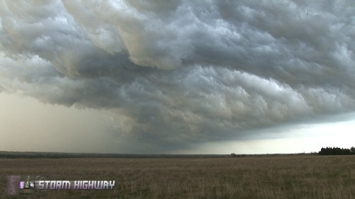
ABOVE: A 'whale's mouth' post-shelf cloud formation southeast of Ellsworth, Kansas.
Click any thumbnail on this page to view a larger version. All images are from video unless otherwise noted.
HD EXPEDITION VIDEO: Timelapse of 'whale's mouth' under shelf cloud: Watch Video
ELLSWORTH, KS - We started the day in Pratt and covered ground from Great Bend, Hays, Russell, Ellsworth to McPherson. Tuesday's setup originally promised a major outbreak of tornadoes, but very early on, the day's prospects diminished considerably as a large line of storms fired from Texas to Nebraska. Nonetheless, one storm managed to go tornadic on the dryline near Hutchinson, Kansas. Where were we? Shooting a bright rainbow and a massive 'whales mouth' cloud formation 20 miles away. We had given up on the day 30 minutes earlier, after a long, hard day of driving and waiting in vain for storms to fire and then for them to produce.
We began the day at the Great Bend library with Brian Sterz, Rich and Ryan Thies and Jeff and Kathryn Piotrowski. A squall line has already develped early in the day and was pushing east through Kansas and Oklahoma. The dryline remained well behind the early storms, allowing for a nice region of untapped surface moisture between the two, and under clear skies. The result would be moderate instability by late afternoon, which we expected to allow the dryline to fire by evening.
We moved east slowly with the dryline along I-70 until storms finally began to fire in the vicinity of Russell. An obvious boundary was visible just north of I-70, and the new storms were tracking toward it. We drove north a short distance to check it out. A highlight of the day ended up being us crossing this boundary with arms out the window, feeling the air go from ~79F to ~55F instantly. Comfortable T-shirt air to chilly jacket air in less than an inch! We crossed this several times in the car, and then stopped, got outside, and let it pass by us. Just like May 11, 2004 in Aberdeen, SD, but not quite as much of a temperature difference. Still very cool. We noticed that the cold side of the boundary was surging southward rather quickly, so we knew we had to move south.
We hopped down the firing dryline all the way to 20 miles north of Sterling to keep up with each tail end storm. Southwest of Ellsworth, everything looked terrible on radar and in person. A loose USB cable stopped my WxWorx data stream, which would require a reboot. I didn't bother. After a chat with Jeff and Kathryn Piotrowski, Dave Hoadley, and Craig Maire at a small chaser convergence, I gave up on the day and decided to start heading east for Wednesday. A vivid rainbow and spectacularly cavernous and contrasty whale's mouth got our attention for the next 20 minutes.
 

Digital image by Matt Robinson

Digital image by Matt Robinson

Digital image by Matt Robinson
The mental exhaustion of a long and unproductive day influenced our decision making, and cost us the tornado(es). When we finally came to our senses and made it to the Sterling storm, it was long since done. We did get some great shots for the day, but not of tornadoes. We ended the day at Montana Mike's in McPherson for a steak dinner with the StormNet crew (Steve Marshall, Craig Maire, Jack Kertzie). We didn't get our celebratory steaks on Monday, so we made up for it today.
| View 1,601 storm chases: |
| by year: |
|
| by type: |
|
|
|
|
My work is, at this very moment you are reading this, generating the most income it ever has in my career. Yet, I was forced to shut down the professional side of my successul operation, against my will, due to one cause alone: 95% of that revenue is being stolen by piracy and copyright infringement. I've lost more than $1 million to copyright infringement in the last 15 years, and it's finally brought an end to my professional storm chasing operation. Do not be misled by the lies of infringers, anti-copyright activists and organized piracy cartels. This page is a detailed, evidenced account of my battle I had to undertake to just barely stay in business, and eventually could not overcome. It's a problem faced by all of my colleagues and most other creators in the field. |
GO: Home | Storm Chase Logs | Photography | Extreme Weather Library | Stock Footage | Blog
Featured Weather Library Article:
|