 Bluegrass Kentucky storm chase day - first of spring 2009: April 5, 2009 Bluegrass Kentucky storm chase day - first of spring 2009: April 5, 2009
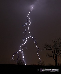
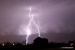
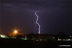
ABOVE: Lightning in Lexington, Kentucky on Sunday, April 5.
EXPEDITION VIDEO: April 5 chase, Kentucky/West Virginia: Watch Video
Click any thumbnail on this page to view a larger version.
LEXINGTON, KY - It's been a long time since I've done a chase log like this, I know. I've been wanting to get back to doing these like I used to do in my earlier years of lightning photography. I've also come full circle in my opinion of evangelism strategy - and that is, there doesn't really need to be one. The best I can do to spread the message of the Gospel is just to speak from the heart, without trying to be careful not to offend anyone. That seems to make more of a difference in reality anyway - trying to be too PC really kills the message (the lack of response I've seen in recent years really confirms that more than anything). The Gospel offended people when Jesus talked about it, when the Apostles talked about it, and when the early followers of Christ's teachings talked about it. Some of them were tortured and killed for it - and it even continues today in parts of the world. In light of that, the least I can do is not let the prospect of someone being offended or thinking I'm crazy keep me from the very reason I'm on this earth - which is passing on the most important message anyone will ever hear.
So, in that thread I want to point you to a favorite speaker of mine, John MacArthur. This guy really knows how to present the message. Some of my friends and I are working on a long-awaited revision to the old Message page that used to be on this site (I took it down because the videos really needed updating). A note to fellow Christians, we could really use your prayers to get this thing off the ground - it's been a challenge to keep things moving on it. In the meantime, the MacArthur page is more than capable of filling the gap: "Who do you think that I Am?" by John MacArthur.
So, on to the chase. I wasn't expecting to be heading out on an all-day storm chase expedition on Sunday, to the point of going out to a leisurely lunch with friends after church. Consequently I hadn't been keeping up with the approaching setup, and only decided to chase after I checked the SPC's Day 1 outlook when I got home around 2PM. A beginner's chase tactic, I admit - but really, I don't bother with intense storm forecasting (morning hand analysis, multi-model comparisons, etc) for events east of I-75, as targeting is more dependent on the limited road networks regardless of the setup. You can't target a triple point or outflow boundary in Hazard, KY for instance - not gonna happen. You just head to I-64 and hope something crosses the interstate at some point. At 2PM, I didn't think I had time for detailed analysis anyway - and I didn't really feel like it either. I just wanted to jump in the truck and head west for a well-needed relaxing afternoon of driving - so that is what I did.
The basic setup was a surface low under an advancing upper trough. A warm front was draped across southern WV and into eastern and northern KY, slowly moving northeast. The surface low was in southern Illinois (with considerable thunderstorm activity at its center), moving east-northeast with a cold front extending south-southwest. Surface winds in the warm sector were generally south-southeast, and pulling better moisture northward as the day wore on. Aloft, a potent upper trough was moving in, spreading strong mid and upper-level winds over the region. Areas of clearing were present across central and eastern Kentucky, providing some insolation for instability. With the proximity of the low, the deepening moisture, the advancing cold front and the upper support, severe storms and tornadoes were possible ahead of the cold front in central Kentucky. Like I said, I didn't do any detailed analysis looking for surface features or jet streaks aloft. I figured the SPC's synopsis of the day was good enough, and Lexington was as good a target as any, with decent terrain and interstate road options in all directions.
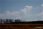
As I neared the northern edges of the warm frontal zone near the Cabell/Putnam county line (still in West Virginia), tiny cirrocumulus clouds with virga streaks appeared. This is a somewhat rare feature I only see a couple of times a year - almost always in association with an approaching warm front:
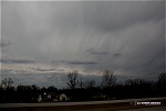
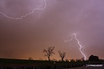
The rest of the afternoon was more of a leisurely Sunday drive westbound than a chase. The RUC and WRF models didn't call for anything near Lexington until sunset, and I didn't want to go much farther west than that. So, I just took my time, taking some back roads here and there. Finally, the action on the cold front sent a nice cell through Louisville on a course to cross I-75 somewhere north of Lexington, so I headed that way. Here are two views of the approaching storms - the first view looking due west from just north of Georgetown, the second of some mammatus looking north from about the same location:
 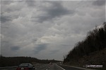
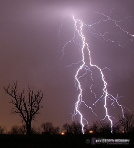
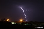
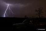
I exited at Corinth and drove for some distance on back roads until I found a suitable observation spot. Lightning was becoming visible to the west and north, but the storms were weakening rapidly. I rolled tape on the storm for about 10 minutes (catching nothing) before deciding to head back to Lexington to catch new development on the cold front to the southwest. I found a great viewing spot just off of I-75 at Man-O-War, in a new housing development with few trees and plenty of open space. The WKYT and WTVQ towers were also in plain view, contributing to the "optimal-ness" of the spot.
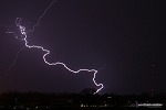
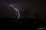
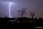
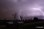
The cell just to my southwest exploded just before hitting Lexington, putting on a great lightning show.
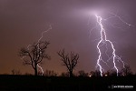  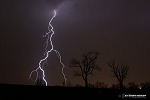 
   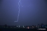
The last image above is a frame from the HD video camera showing a strike to the WKYT tower. It is hard to see in this image, but the channel is connecting to the side of the tower about 300 feet below its top - more evidence that lightning doesn't always strike the highest spot!
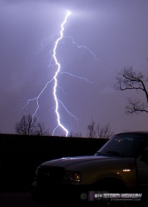
This was my new truck's first 'real' chase (I bought it in early March after my Freestyle's demise), so a I took a few frames to commemorate the occasion:
When the storm's core finally hit a few minutes later, I was blasted with nickel-sized hail as I scrambled to get the video camera back inside (it was porta-braced, so no water problems). Small hail is still pretty painful! Hail briefly filled the drainage ditch along the road, but melted quickly. It was too dark to get any photo or video documentation of the hail barrage, though I tried.
When I looked at a radar loop immediately after the passage of the core, I thought I might be able to sneak through a gap between cells and get ahead of the line on I-64. Everything was moving fast, but in a northeasterly direction. With I-64 heading fairly due east, I thought I had a chance. No such luck! I stayed pretty well right behind the cores all the way to Ashland! A rear-wheel drive pickup is not a vehicle known for stability in heavy rain, so I took it slow (50-55mph). I finally got a chance when things let up just before the state line, accellerated to 65, and broke through to dry pavement passing through Huntington! I saw several power flashes to my north as the line hit the Pomeroy, OH area.
All the effort to beat the line home was for naught though, as new convection had already formed ahead of the line and was passing through Charleston. I decided to just stop in Teays Valley and let the original squall line roll over me, with the hopes of grabbing a couple of WVAH tower strikes. Again, I experienced a brief intensification of the cells as they arrived, with winds topping 50mph, knocking power out in Scott Depot as I watched (see video). No tower strikes with the narrow line of storms though. I arrived home just after midnight in the midst of the last weak cell passing over town, with a few final flashes of lightning and quiet rolls of thunder to end the first storm chase day of spring.
GO: Home | Storm Chase Logs | Photography | Extreme Weather Library | Stock Footage | Blog
Featured Weather Library Article:
|


