|
Home | Blog Index | Blog Archives | Christianity & Faith Essays | Storm Chasing Essays
May 1, chase standby on the horizon
After a long winter, we've finally reached one of the dates we've been waiting for. May 1, the start of our annual chase standby period, is now within the window of the 14-day GFS forecast model. That means we can start our forecasting excercises in an attempt to narrow down the departure date for our storm chase expedition.
As we've talked about last year, computer forecast models are very unreliable beyond 5 to 7 days, and virtually useless past 14 days. Models often flip-flop wildly in the long term (and even in the short term), giving us a 'roller coaster ride' from optimism to hesitation and back several times. Any forecast we derive from the models beyond day 7, therefore, must keep this fact in mind. While the 7- to 16-day models can be unreliable, they nevertheless can give us a rough idea of what the large-scale patterns might end up doing. This is particularly true if the models maintain a consistent forecast day after day. And since the long-range models are all we have to plan with, we try to work with whatever information we can get from them.
So, with that in mind, let's take a look at what the GFS model is suggesting for May 1. Here is the GFS 500mb forecast for the first day of May:
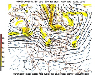
14-day GFS 500mb forecast
This image does not suggest a western trough in progress or approaching for the first few days of May. On this map, two small troughs are positioned across the north-central and northeastern USA, with a ridge (the opposite of a trough) out west. If the GFS is correct, May 1-3 - and possibly several days later - will probably not be the time for us to leave.
At this point I want to take a minute and explain what the significance of the 500mb map is. Our main focus with the extended models is the large-scale pattern on the 500 millibar forecast image. 500mb refers to a level in the atmosphere some distance above the surface layers, sometimes referred to as the 'mid-levels'. The models plot the pressure contours and wind direction at this altitude. Because the 500mb pattern is usually the 'indicator' of the overall large-scale pattern and jet stream path, we (and all storm chasers) use the 500mb forecast map to look for the pattern that is most conducive for tornadoes on the Plains: the west coast trough. The west coast trough will show up as a big 'dip' over the west coast/Rocky mountains on the '500mb' map.
Why is a western trough important for tornadoes? First of all, surface winds ahead of a trough tend to be southerly, resulting in a 'conveyor belt' of wind that pulls healthy moisture off of the Gulf of Mexico and transports it northward into the Great Plains. This provides fuel for storms and helps sharpen the 'dryline' boundary with the hot, dry air in the desert southwest. Second, low pressure systems develop along the periphery of the trough and move out over the Plains, providing a focus for storm development and low-level wind shear. Third, 'jet streaks' of high winds in the mid- and upper-levels of the atmosphere ride around the trough and move either close to or directly over the good moisture and wind shear, providing additional shear and assisting storm development. A slow-moving western trough can result in several days of prime tornado conditions on the Plains. In a typical spring season, a series of troughs will move through, one every week or so - with several good storm chase days in a row followed by a few 'down' days between events.
The 7-day GFS forecast shows a moderate-sized western trough for the April 22-24 timeframe:
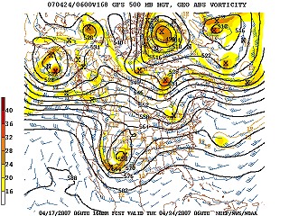
7-day GFS 500mb forecast
So why are we not excited about the April 22-24 trough? The reason is because the unseasonably cold weather we've had in the last week or so has reached all the way to the Gulf of Mexico, meaning that this new trough will not have as much moisture in place as one will later in May. Dewpoints over the Gulf are reading in the 40s and 50s now, due to cold frontal passages pushing the moisture far to the south. We would like to see Gulf dewpoints in the mid 70s as far north as the Texas and Louisiana coastline, which would mean there is plenty of good moisture that can be transported north. The April 22-24 trough, while looking somewhat good for tornadoes, will not be 'all it can be' due to the lacking moisture.
After April 24, the GFS shows a deep trough settling in over the eastern USA, suggesting little chance for severe storms on the Plains through the end of the month:
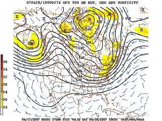
12-day GFS 500mb forecast
So, we've all but eliminated the last half of April for a departure date, mainly due to the low surface dewpoints over the Gulf of Mexico and the lack of a good western troughing pattern suggested by the models. The first few days of May, based on the current GFS run, may also not be a good time to leave. Of course, this can all change with future outlooks. But for now, we'll adjust our probability table to reflect the data we've just looked at, giving more weight to the later days of May.
Based on the current outlook, this probability table charts the chance of our trip starting on a particular date:
| 2007 Storm Chasing Expedition - Departure Date Probability as of April 17 |
| April 21-30 | 3% | |
| May 1-10 | 20% | |
| May 11-20 | 25% | |
| May 21-31 | 25% | |
| June 1-15 | 25% | |
| No trip | 2% | |
|
GO: Home | Storm Chase Logs | Photography | Extreme Weather Library | Stock Footage | Blog
Featured Weather Library Article:
|


