| Home | Blog Index | Blog Archives | Christianity & Faith Essays | Storm Chasing Essays
Vehicle work part 2; Plains trip possible
Last night, I arrived home in New Baden, bringing to a close a week-long 1,890-mile trip across 8 states for my early-spring family/friends visiting circuit (in WV, NC and PA). Aside from the chase vehicle work in Raleigh last week, I've been too preoccupied with either driving or visiting - and thus have had no time to pay any attention to the blog and/or forecasting for the upcoming severe weather setup in the Plains later this week.
Now that I'm back home and semi-caught up with work, I decided to give some attention to a blog update, as there is a potentially active chasing period coming up.
Vehicle work update 2
First an update on the truck. I ended up having an extra day in Raleigh due to rain postponing my trip west (I was hauling some furniture from Raleigh back to my STL apartment, and needed two clear days for that trip). As a result, I was able to get most of the finishing touches done on the power console setup, as well as refining the dashcam mount. I had originally planned on simply hanging the power rig on the back interior panel under the window. This was mostly stable, except for some slight sliding back and forth during sharp turns. I decided I wasn't satisfied with that, so I bolted the rig to the panel in four spots, with spacers keeping the rig about a half-inch off of the wall.
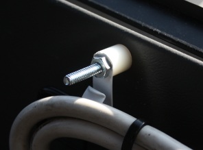
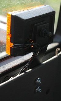
While I had the panel removed, I also bolted on the rear-facing amber strobes:
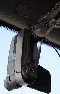
The dashcam mount modifications consisted of adding a rigid aluminum 'harness' for the camera, with a single angle brace. Unlike the previous velcro straps, this completely eliminates vibrations and slow creeping out of alignment. I also re-oriented the camera to include more sky in the image, while maintaining the coverage of the road.
So with that, the truck is finally in full 'spring-summer chase mode'.
Storm chasing forecast update
For much of my trip after Saturday, I was without internet access (aside from my phone) and therefore unable to look at models and do much of any forecasting. The chase community had been abuzz about this upcoming week, but up until this morning I had no way of looking at data for myself. The 00z GFS and NAM models both paint a nice setup just west of the Texas/Oklahoma border area into the Texas Panhandle on Thursday, extending into southwest Kansas. Under strong southwest upper-level winds from an arriving trough, low-level wind fields and moisture along the dryline look good for supercells and tornadoes in this area. Both models break out abundant precip in this area by sunset. My concerns with this day are weak capping strength (tail-end charlie day) and questions about moisture return. After Thursday, the system moves east into Oklahoma on Friday and then Arkansas on Saturday, with supercell potential each day. Right now I'm considering a multi-day trip to pursue all three days, which would lead me eastward toward home with each successive chase.
I've always had fun with the old chase probability tables, so I'm going to continue those this year. But since I'm now only a afternoon's drive away from the Plains and able to do more short trips, the planned 'chases' will be less like they used to be (that is, not the one or two long, major trips). This year, I'm switching the probability table configuration to reflect the level of expectations that a chase will take place during set 4 to 7 day time intervals. That is, all percentages are separate, single 'yes-no' values rather than season-long values adding up to 100%. For instance, the probability that I'll choose to pursue the Plains during April 21-24 is 60 percent, with a 40 percent chance of no chasing during those 4 days. The April 25-30 period is completely separate, with a 55 percent chance of chasing (based on long-range models). Due to these percentages being solely determined by long-range forecasts, I can't realistically go much beyond 2 weeks. So, unlike past years, the entire season won't be represented with percentage 'blocks' that add up to 100%. Hopefully all of that makes sense!
So, here is the first table showing the thinking for the upcoming 2 weeks. I am leaning on chasing Thursday's event in TX/OK, but am not completely certain about it - hence the 60% value. That number may go up tomorrow (the beauty of living in STL means I can wait until 00z to make a final decision). For next week, the GFS and EURO hint at another trough possible - but due to this being so far out, 55% values leaning toward chasing seem appropriate. For May 1-5, I don't see a solid pattern shown either way, so this block is at 50% chase/no chase. (The last date block on these tables will likely always be at or near 50% unless there is remarkable model agreement/consistency).
| 2010 Storm Expeditions - Probabilities as of April 19 |
| April 21-24 | 60% | 
|
| April 25-30 | 55% | |
| May 1-5 | 50% | |
|
|


