|
Home | Blog Index | Blog Archives | Christianity & Faith Essays | Storm Chasing Essays
Last-minute preps, tornadoes already happening
As you can see, this blog is kicking in to high gear as things get going. I'll likely have 1 to 3 updates per day here during our trip, as time and internet access permit. The potential for this week seems to really be coming together. Tornadoes have already been reported in Nebraska on Friday, with more expected today in the Texas panhandle. The setups for Monday-Wednesday look very encouraging and we are optimistic. The SPC's Day 3 outlook for Monday is now out, with a nice hatched area down the dryline.
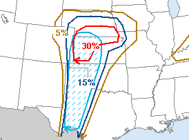
SPC outlook for Monday
Lord willing, t-minus 7 hours or so before I get on the road heading west. On a normal storm chase expedition from West Virginia, I usually don't leave until the 12z model runs come out about noon or so and the SPC issues their new Day 2 outlook (for the following day) at 1:30PM. The new model runs and SPC outlook are the last new data for the next day's prospects I can get, and still make the target on time with a short night's sleep on the way. In other words, normally I'd be waiting until 1:30PM on Sunday to head west for Monday's chase. That way, I have every chance to back out if the chances for tornadoes decrease. But with a typical Plains trip target, in order to make it in time, it's a non-stop drive from WV that leaves me about 5 hours to sleep somewhere in central Missouri. Waiting for the 00z model runs (which come out in the late evening) would leave me no time to make it, even if I drove straight through with no sleep.
This time, with Matt's flight reservation made and paid for, I'm committed to making the chase at this point. The downside to that is that if the outlook for tornadoes diminishes at the last minute, we can't back out. The upside, though, is that I don't have to wait until the last possible minute to leave here. That translates to a much easier drive, and time for full night's sleeps before the storm chase days begin. I can enjoy the drive, under the speed limit, stopping for limited sightseeing and photography here and there. No pressure to get somewhere 1000 miles away by the next morning. Consequently, I'm planning on heading out today as early as possible, and aiming for somewhere from St. Louis to Joplin for the first night's stay. After church, it's another leisurely drive to Oklahoma City, where I won't need to be until 10PM to pick Matt up from Will Rogers airport. More than plenty of time barring any problems. There is a small risk for severe storms in southern Missouri and northeast Oklahoma on Sunday afternoon, which I may have time to check out. After I pick up Matt in OKC, we'll drive a couple more hours west on I-40 (Elk City or thereabouts) to be in position to make any target in the Texas panhandle, western Kansas or southeast Colorado on Monday.
Forecast and target
The latest NAM/WRF model output shifts Monday's risk slightly to the east, centered on the Texas/Oklahoma border. However, our preliminary rough target will remain Amarillo, Texas. If the risk shifts back west or north (as is still possible this far out), shooting for Amarillo will leave us some time to adjust accordingly. There is some concern now, based on the latest NAM output, that the surface low and better upper dynamics might remain too far west of the moisture and instability. However, this would simply mean tornadoes happening more toward dark rather than in the afternoon. Tornadoes harder to see and photograph, but tornadoes nonetheless.
Based on the current outlook, this probability table charts the chance of our trip starting on a particular date:
| 2007 Storm Chasing Expedition - Departure Date Probability as of April 21 |
| Red - main expedition; Blue - April 22-30 |
| April 22-30 | 99.9% | |
| No April trip | 0.1% | |
| May 1-10 | 24.5% | |
| May 11-20 | 24.5% | |
| May 21-31 | 24.5% | |
| June 1-15 | 24.5% | |
| No main trip | 2% | |
|
GO: Home | Storm Chase Logs | Photography | Extreme Weather Library | Stock Footage | Blog
Featured Weather Library Article:
|


