|
Home | Blog Index | Blog Archives | Christianity & Faith Essays | Storm Chasing Essays
DAY 4: Challenging day in central Kansas
We're currently in Wichita, Kansas for the night, after starting the day in Pratt and covering ground from Great Bend, Hays, Russell, Ellsworth to McPherson. Tuesday's setup originally promised a major outbreak of tornadoes, but very early on, the day's prospects diminished considerably as a large line of storms fired from Texas to Nebraska. Nonetheless, one storm managed to go tornadic on the dryline near Hutchinson, Kansas. Where were we? Shooting a bright rainbow and a massive 'whales mouth' cloud formation 20 miles away. We had given up on the day 30 minutes earlier, after a long, hard day of driving and waiting in vain for storms to fire and then for them to produce. A loose USB connection had just caused my WxWorx data stream to quit, and I didn't bother fixing it because I felt the day was over. So, we turned our attention to the other sights the storms had to offer.
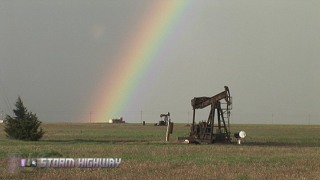
Rainbow and pump jacks
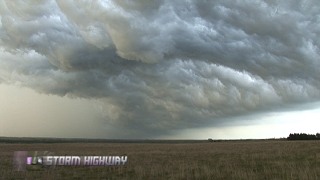
'Whale's mouth' behind gust front
I saw the tornado images that just about everyone else captured today. While I would have loved to have bagged the same thing, I can't say I'm hurting too much after what we were blessed with yesterday. My mistake today was pretty clear-cut. I let the mental exhaustion of a long, unproductive storm chase day influence my decision making - rather than sticking to time-tested chasing tenets (like not giving up it out until the day is over). A lot of chasing is sticking to the realities of what is happening rather than what you're feeling. I knew that the day shouldn't be over until the last tail-end storm dies, but the trends of the day got the best of me. That, and the lack of radar to alert me to what was happening to the south, cost us the tornado(es). Nonetheless, I am happy with the images that we captured in leu of the tornado event.
I'll write more about Tuesday's (and Monday's) chase later on when I've got more time.
Tomorrow, we've got one more Great Plains trip in southeast Kansas/northeast Oklahoma that will conveniently take us a little further east toward home. After that, it looks like we'll have a possible lightning chase from Indiana through Kentucky on Thursday. We'll arrive in Raleigh late Thursday or Friday, when yet another storm chasing chance will be had from the same system we will have been following across the country. After that, I'm heading back to West Virginia, at which point I'll return to long-range forecasting mode for our main storm chase expedition in May.
More tornado images from Monday
Matt has gone through some of his digital photos (Canon 5D) of the Protection, Kansas tornadoes, and has posted a few of them on his web site at raleighskyline.com.
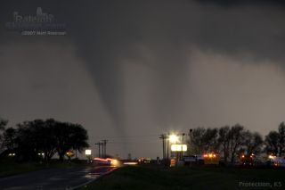
Protection, Kansas tornado #2, by Matt Robinson
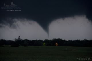
Protection, Kansas tornado #3, by Matt Robinson
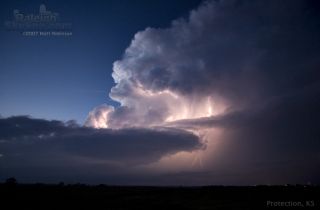
Protection, Kansas supercell at dusk, by Matt Robinson
GO: Home | Storm Chase Logs | Photography | Extreme Weather Library | Stock Footage | Blog
Featured Weather Library Article:
|


