|
Home | Blog Index | Blog Archives | Christianity & Faith Essays | Storm Chasing Essays
DAY 5: Low-topped supercell in southwest Missouri
I'm typing this from the car next to Busch Stadium in downtown St. Louis while Matt shoots some skyline photos. After leaving Wichita, we played around with some cold-core storms in southeast Kansas and northeast Oklahoma today, covering ground from Sedan, KS to Bartlesville, OK. The activity was not showing much promise after a few hours, so we decided to begin the trek back east toward home.
After passing through a developing cell's precip core on I-44 at Springfield, I looked back to see this, and promptly exited the highway:
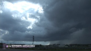
Rain-free base at Springfield, MO
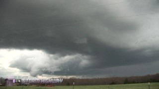
We followed this storm north for the next two hours. At first, we drove right up under the area where the wall cloud was trying to condense. As we approached, cool west winds suddenly turned to southeasterly inflow. We watched for a while longer, when a large RFD slot developed and the lowering grew larger. Rising motion was modest but persistent. The base took on a rounded appearance with a horseshoe shape.
After a few minutes, the small wall cloud's rotation and rising motion increased, and condensation began reaching downward further. The huge RFD cut was very impressive. The storm was tiny with meager inflow at the surface, but nonetheless, at this point the overall structure was getting me excited.
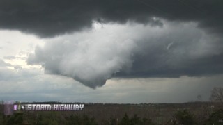
A few times, a pointy tail cloud condensed diagonally toward the ground, making the lowering a classic 'fakenado'. So much so I wondered how long it would take for someone to report it as a tornado/funnel cloud.
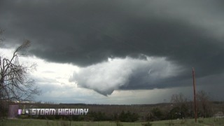
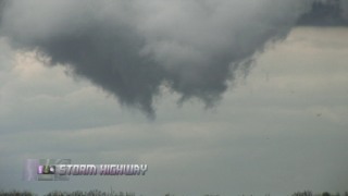
Here is the wall cloud at its lowest point. Persistent and clear rotation was noted here. If this had gone on for another 30 seconds, I would have called it in.
We saw only one other chase vehicle on this cell. A nice catch for a day that initially promised little.
We're headed to Evansville, Indiana for tonight's stay. A marginal but widespread severe weather risk will be present for the continuance of our eastward trip tomorrow through Kentucky and yes, West Virginia. We'll likely stay at my house in Charleston tomorrow night, and make the final trip to Raleigh to get Matt back home.
GO: Home | Storm Chase Logs | Photography | Extreme Weather Library | Stock Footage | Blog
Featured Weather Library Article:
|


