|
Home | Blog Index | Blog Archives | Christianity & Faith Essays | Storm Chasing Essays
Snow complications and tower lightning
Such is the drawback of having a job that revolves around the weather. It looks like I may have to postpone my trip to Raleigh until Saturday or Sunday. Last week, I mentioned the potential for snow indicated on the models, and it looks like they were correct. The models are coming into agreement on sending a clipper-type low pressure system through West Virginia on Friday and Saturday, with good precip signatures showing up on the GFS model early Saturday morning. Temperatures will be not far above freezing during the day and well below freezing from evening to morning, and temperatures aloft (in the atmospheric layers of air above the surface) will be much colder. This means any precip will be in the form of snow.
An accumulating snow event in Charleston is one I can't afford to miss, so I'll be hanging around a couple more days before heading southeast. I'm actually hoping the clipper dries up or moves north, as the Raleigh family get-together was something I was looking forward to. I'll be watching the data closely in the coming days to see if the snow will pass Charleston by and allow me to make my trip as planned. The worst-case scenario is that I'll leave for Raleigh on Sunday once all the snow is clear of West Virginia, and still have a little bit of time to spend with everyone.
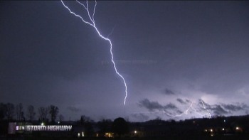
Switching the topic from snow to thunderstorms now. I caught my first upward lightning discharge of the season on Tuesday night at the trusty WVAH tower near St. Albans. After two years of shooting the tower strikes up close, this year I will be focusing on getting more wide, distant shots of these sky-filling discharges. Click on the image below for more screen shots, a video clip and the chase report:

April 3, 2007 tower lightning
| View 1,609 storm chases: |
| by year: |
|
| by type: |
|
|
|
GO: Home | Storm Chase Logs | Photography | Extreme Weather Library | Stock Footage | Blog
Featured Weather Library Article:
|