| Home | Blog Index | Blog Archives | Christianity & Faith Essays | Storm Chasing Essays
Finally, some weather stuff to watch
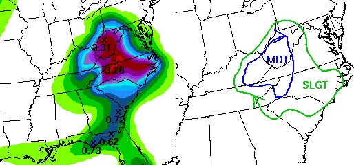
HPC 24-hour precip forecast and flooding risk
The first drops of rain are falling outside as the remnants of Tropical Storm Fay are finally making their way across our region. The HPC precip forecasts show a moderate probability of excessive (flooding) rainfall, with 3 to 3.5 inch totals forecast over much of WV. The NWS seems to disagree, not yet pulling the trigger on a flood watch - citing the speed of the system, the dry ground and the low stream levels from nearly 2 weeks of precip-free conditions. Looking at radar, I'm tending to lean in the direction of agreeing with the NWS - the current precip shield does not look large, intense or slow enough to do much in the way of bringing streams up to flood levels. The caveat, as always, is the mountains, which can locally enhance or diminish rainfall totals. For this reason I would think the higher rainfall totals will be on the eastern slopes, due to the southeasterly upslope flow from Fay's surface circulation. SE flow tends to put Charleston and western WV in a mountain-induced 'rain shadow' of lesser precip rates.
Any flooding we do get will probably be very late tonight or early tomorrow morning, so I don't plan to do much with this event, if anything at all.
Meanwhile, Gustav has reached hurricane status in the Caribbean, and is heading for the warm, open waters of the Gulf of Mexico. The storm's track is taking into an environment very favorable for rapid and deep intensification. With no major blocking/steering factors expected anytime soon in the Gulf region, this storm will likely make landfall next week along the Gulf coast as a major hurricane.
Keep an eye on things; The prediction for our area was 5 inches of rain max., however since Monday afternoon we've recieved (at my house) a little more than 9 inches. Flood levels are the highest since I moved here a decade ago.
- Posted by David Rowh from Salisbury, NC | |
|


