|
Home | Blog Index | Blog Archives | Christianity & Faith Essays | Storm Chasing Essays
Storm update 4: Snow possible Sunday afternoon and evening
Subfreezing temperatures statewide in West Virginia seem to be a settled issue with the models by Sunday afternoon as a strong cold front gets pushed through by the departing low pressure system. The question now seems to be with how much precipitation will remain with the departing storm after the changeover to snow takes place. An earlier changeover will mean more snow, a later one will mean less. Both the GFS and WRF show the last bit of precip from this system lingering through Sunday night statewide and into the mountains through Monday.
Pinning down accumulation totals is always a toss-up even for experienced meteorologists, but for now I'd say Charleston could see anywhere from a dusting to three inches. This will be highly dependent on how fast the transition from snow to rain takes place, how fast the temperatures drop and the locations where any heavier banding sets up into the evening.
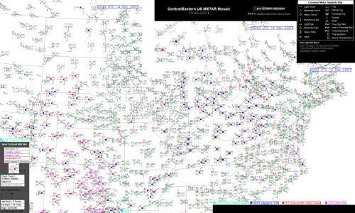
New METAR Map Mosaic
I got tired of always clicking back and forth between regional METAR maps to keep track of approaching storm systems, so something I've been experimenting for a while is a stitched-together image of several NOAA METAR data maps that shows weather observations for a big chunk of the country. I added a couple more tiles to the mosaic this week and decided to make it a public page now. Using this map, you can see surface conditions from Montana down to Texas and all the way to the Atlantic coast, all on one big image. Anything heading toward West Virginia and the east coast within a period of a couple of days should be visible on this map. Since the mosaic is table and not CSS based, in theory it should be cross-browser compatible. I added a couple of graphical keys to this page to help you interpret the symbols if you're new to reading METARs.
DATA LINK: Central/Eastern METAR Mosaic
GO: Home | Storm Chase Logs | Photography | Extreme Weather Library | Stock Footage | Blog
Featured Weather Library Article:
|


