|
Home | Blog Index | Blog Archives | Christianity & Faith Essays | Storm Chasing Essays
Flood potential in Kentucky and West Virginia tonight
As expected, training heavy rain associated with a stalled frontal boundary is setting up across Kentucky tonight. This image shows the radar-estimated precipitation totals for today so far, indicating several swaths of one-inch plus amounts across Kentucky:
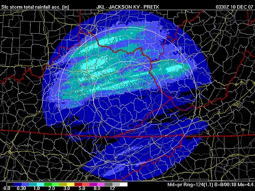
While one inch of rain over a few hours is not usually enough to cause high water problems, this rainfall has saturated the ground so that further heavy rain will have nowhere to go but into the creeks and streams. Radar indicates heavy rain and even some thunderstorms moving across the area toward the Charleston-Huntington corridor, and flooding has already been reported in Kentucky generally along and south of I-64. Flood watches have been issued for most of the area through tomorrow morning. Top all of that off with some rare December lightning displays, and it looks like an active night that I'll need to stay up and keep an eye on.
GO: Home | Storm Chase Logs | Photography | Extreme Weather Library | Stock Footage | Blog
Featured Weather Library Article:
|


