|
Home | Blog Index | Blog Archives | Christianity & Faith Essays | Storm Chasing Essays
Norman 'shield' moves to Charleston
I got a laugh when I saw this today. There is a long-running joke among storm chasers that there is an invisible 'weather shield' or 'bubble' over Norman, Oklahoma, a suburb of Oklahoma City. Norman has had a remarkable track record of barely missing out on most major snowstorms, ice storms, severe thunderstorms, tornadoes or any number of 'interesting' weather events - leaving its residents with seemingly endless, uninteresting, boring weather - much to the chagrin of weather-fanatic OU students and local storm chasers.
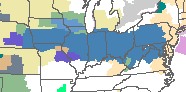
Charleston appears to have contracted the Norman Bubble this week. The images below show the current National Weather Service watch/warning display for the US. The blue areas are counties under a Winter Storm Watch in anticipation of a major snow and ice storm event. Notice the solid winter storm watch extending from Nebraska nearly to the Atlantic coast - with the exception of a few counties in a certain area of West Virginia.
Zooming in:
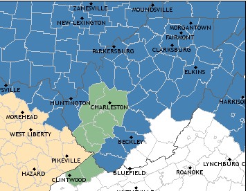
While the effects of the 'Norman Bubble' is at worst fictional and at most coincidental, our 'bubble' here can be a real weather phenomenon. The Appalachian mountains sometimes act as our own 'weather shield'. In the winter, warm air at or near the surface has a tendency to get trapped on the west side of the mountains, unable to move east and allow colder air to flow into the region. This area of trapped warm air is called the 'warm wedge' (which I've discussed before on this blog). When a warm wedge is present, areas just west of the high terrain (like in Charleston) will remain above freezing, seeing only rain - while everyone else is seeing heavy snow and ice accumulations. This is the case now, with an ice storm expected in Huntington and Beckley - but all rain in Charleston.
In the summertime, the mountains tend to cut off moist, southerly low-level flow from the south, choking off inflow for thunderstorms moving in from the west. Many storms in Ohio and Kentucky fizzle before reaching the state line due to this real-life 'weather shield'.
Norman, I feel your pain.
GO: Home | Storm Chase Logs | Photography | Extreme Weather Library | Stock Footage | Blog
Featured Weather Library Article:
|


