| Home | Blog Index | Blog Archives | Christianity & Faith Essays | Storm Chasing Essays
Long, cold winter days ahead
About this time of year, I start watching the models for glimmers of hope in the form of a warming trend somewhere in the future. Yes, winter is far from over at this point - but sometimes even in February, the first surges of warmth from the south can be seen organizing for their eventual battle northward at the far ends of the long-range models. Sad to say, today I see no such sign. Everything points to another long-duration frigid surge - plunging temps back to well below normal values across the entire central and eastern US for a week, maybe even two. Model consensus seems to establish a persistent cold-air 'conveyor belt' (northerly flow pattern) that just keeps pumping Arctic/Canadian air from the north down across the central US which then fans out across the south and east.
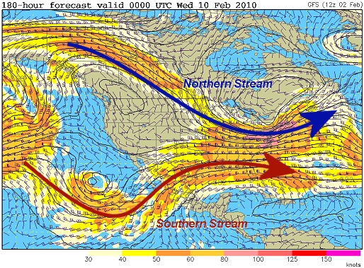
Nonetheless, the overall upper air patterns remain active - in a 'split flow' configuration over the USA with frequent troughs/ridges passing through. A split flow pattern features two distinct jet stream paths affecting the continent rather than the usual single stream - referred to as the 'northern stream' and 'southern stream' (I added the arrows to this graphic to show the n/s stream jets):
GFS 500mb pattern for next Tuesday
In most winter cases, the southern stream marks the main boundary between the 'real' warm, moist air in the lower latitudes and cold air to the north. That is, we need the southern stream to be our dominant weathermaker in the US if we want any decent warmup or good chances for storms. A northern stream jet moving through in the winter typically will be working with colder air and won't have as much moisture available for thunderstorms. Unfortunately, the southern stream is staying too far south to allow any real warmup/thunderstorms for any locations north of the Gulf coast regions. Both northern and southern stream systems can produce winter storms, either together or separately - which is what we've been dealing with lately and will be for the next week or so. Yet another major storm will affect the country later this week, possibly dropping another foot of snow in the WV mountains into the VA/NC Piedmont. For St. Louis, the aforementioned storm may drop a few inches of snow on Thursday-Friday as it gets organized during its trek eastward.
Other than that, it's just a matter of riding out the rest of this month. It won't be too long. Eventually we will start seeing those signs of impending spring on the long range models, typically well before March 1. We always know spring will start and win the battle - it's just a question of when.
|


