| Home | Blog Index | Blog Archives | Christianity & Faith Essays | Storm Chasing Essays
Deep winter may be ending!
As I've posted before, I have been watching long-range models with great anticipation for signs of spring, and I think we've finally got something on the horizon. The current pattern that we're in could be the last of 'deep winter' conditions this season, that is, for the mid-latitudes of the USA: lows in the single digits/teens, highs only in the 20s-30s and weekly/biweekly snowfalls. In an average year, we see this stage of winter ending by mid-February, with temps already beginning their climb by March 1. We seem to be 2 to 3 weeks behind that this year, with brutal 'deep winter' conditions lasting right up to and possibly beyond March 1. Not out of the ordinary, but seemingly unusual compared to the past 10-15 years or so.
The glimmer of hope I see on the models right now is a breakdown of the 'death grip' N-NW flow patterns that have pummeled the USA with a constant stream of frigid Canadian/Arctic air. These type of patterns have worked against the seasonal increase in solar heating by continually knocking down any air mass recovery with fresh supplies of high-latitude-originating cold air. Typically by March 1, the higher sun angle has caused a steady increase in surface temps, with only a few lingering hits of cold air and snow here and there. The models seem to agree on the 'winter death grip' pattern changing to either a central US ridge or a western trough by March 7-10. Both of these would mean a warmup for at least the central US states, with the latter possibly bringing the first widespread thunderstorm event to the Midwest and Plains. With either configuration, the model forecast charts show a refreshing picture of warm air surging north.
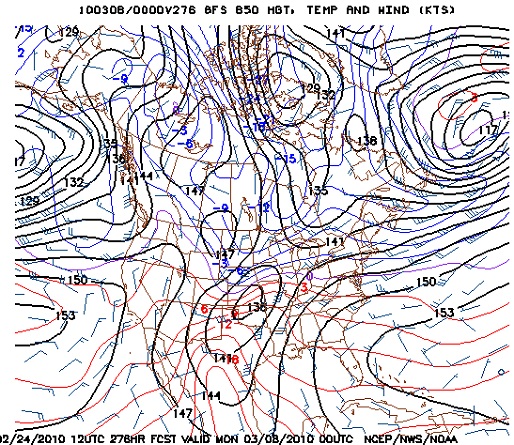
GFS 850mb chart for Sunday, March 7
We're looking pretty far into the extended range here, which means that the specifics of the pattern will probably not pan out exactly like this. However, there has been some consistency and agreement in recent days about an upcoming pattern change from the current one - and with it being March, a resulting warmup is a reasonable expectation. In the event of a western trough, there is always a remote chance of severe weather - but being in early March, more than likely it will be messy rain/general thunderstorm event lacking deep moisture. Nonetheless, even this will be a welcome sight, and I will definitely be outside taking it in if/when it arrives.
Unfortunately, we know that any significant warmup in early March will not last long. As the upper patterns take on their typical spring volatility, we will see the usual back-and-forth swings between winter and spring until early to mid-April, including the ever-present potential for snow events (some major). What I think the good news is, is that we should finally see the 'brutalness' of this winter moving out by this weekend. For St. Louis and Charleston, WV latitudes, this should mean 1.) high temps finally staying above 45 most days with some 50s appearing more and more; 2.) disappearing snowpacks, 3.) no more Arctic air outbreaks, and 4.) any further cold spells lasting only a day or two.
|


