|
Home | Blog Index | Blog Archives | Christianity & Faith Essays | Storm Chasing Essays
High risk far away, KY/OH storms getting closer
Update: 3:55PM Tuesday: Currently sitting at a Starbucks on the Hurstbourne Parkway, Louisville for a brief data stop before continuing. The setup is looking like a nighttime show just to the south and west of here. This area is not in the greatest tornado threat, but the best I could reach in time from Charleston. I will probably drift southwest along the river toward the Owensboro area, where chase terrain and visibility is better. A few weak storms have fired to my south-southwest but are not intensifying much. I may meet some of those in the next 2 to 3 hours. The main event in this region will be later tonight, with very intense winds and possibly a few tornadoes. I will be here for the duration - stay tuned!
Update: 11:26AM Tuesday: Heading to Louisville, Kentucky in a few minutes.
Update: 9:46AM Tuesday: Props to the RUC model! The line of storms in northeast Kentucky and southeast Ohio is really making a push southeastward now, and should arrive in Charleston sometime around noon. The drawback is that the line is weakening as it leaves the forcing support of the front. While it looks certain the line will arrive here, whether or not it will have any lightning left when it does is questionable.
8:38AM Tuesday: I know every storm chaser in the world (literally) knows about this - but we've got our first high risk of the year. The squall line already in Kentucky is going to limit tornado potential anywhere that I can realistically get to today. It turns out the best chances today are in Arkansas, western TN and northwestern MS - way beyond my out-of-season travel range. Based on radar trends, it looks like the RUC model may very well be correct about its earlier forecast of the line of storms moving into the Charleston area today, with some severe weather possible. That's more than enough to keep me in town and give me something interesting to cover. I'll be posting updates throughout the day, so stay tuned.
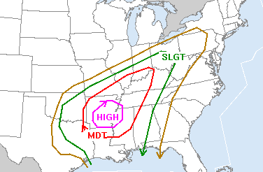
SPC severe storm risk for Wednesday
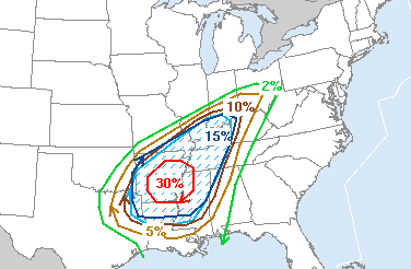
SPC tornado risk for Wednesday
One of the remarkable things about this event to me is how many storm chasers are actually going after this one! I think this may end up being the 'most covered' out-of-season, out-of-the-Plains event in history. I've read forum and blog posts of storm chasers coming down from as far away as South Dakota, Colorado and northern Illinois to try for this setup. For decades, storm chasing has been classically defined as a hobby done in the Great Plains 'tornado alley' from April to June - but more and more storm chasers are waking up to the fact that good storms also happen year-round in other parts of the USA.
Hey Dan, be safe! There's an incredible amount of power in these storms tonight!
Spencer
- Posted by Spencer | |
|


