Storm Highway by Dan Robinson
Storm chasing, photography and the open roadClick for an important message
Storm Highway by Dan RobinsonClick for an important message
Home | Blog Index | Blog Archives | Christianity & Faith Essays | Storm Chasing Essays

                   Monday, January 28, 2008 - 3:38AM

Thunderstorms possible Tuesday night

By DAN ROBINSON
Editor/Photographer
Important Message 30 Years of Storm Chasing & Photography Dan's YouTube Video Channel Dan's Twitter feed Dan's RSS/XML feed

From Dan: How the crime of copyright infringement took $1 million from me and shut down my operation.

In September of 2025, my work is generating the most income it ever has in my career. Yet, I'm being forced to shut down my successul operation, against my will, due to one cause alone: 95% of that revenue is being stolen by piracy and copyright infringement. I've lost more than $1 million to copyright infringement in the last 15 years, and it's finally brought an end to my professional storm chasing operation. Do not be misled by the lies of infringers, anti-copyright activists and organized piracy cartels. This page is a detailed, evidenced account of my battle I had to undertake to just barely stay in business, and eventually could not overcome. It's a problem faced by all of my colleagues and most other creators in the field.

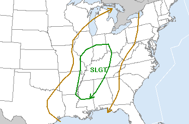
Update 3:30PM Monday: Tomorrow's risk has been upgraded to a SLIGHT for the lower Ohio Valley area (I updated the graphic below). While not a stellar setup for storms by any means, for late January it is something to watch. The limited to no CAPE (instability) forecast for tomorrow means that little more than a pre-frontal squall line can be expected with this (probably with little or no lightning). I think I may save my chase money for a better setup, especially since meteorological spring (March 1) is a little more than a month away!

You know it's the dead of winter when storm chasers start blogging about Day 2 SPC general thunderstorm outlooks (and at 4AM no less). I last saw lightning sometime back in November, so I'm ready to give some attention to something that can break the annual storm drought. Both the NAM/WRF and the GFS show some good heavy precip returns by Tuesday evening along a sharp cold front, though instability is not going to be that great (the NAM/WRF paints none over KY, OH or WV). The best chances for thunder once again look to be in southern and central Kentucky, mainly south of I-64 - which is what one would expect climatologically for a system happening during this season. It would be nice to live somewhere around Lexington (hey, maybe that's an idea - more on that later).

Charleston has a shot at seeing something with this, so a chase westward isn't in my plans at this point - but that is subject to change. I don't expect much, but I'll be keeping the cameras charged up and loaded as always.

30 Years of Storm Chasing & Photography
Important Message
Dan's YouTube Video Channel
Dan's Twitter feed
Dan's RSS/XML feed

GO: Home | Storm Chase Logs | Photography | Extreme Weather Library | Stock Footage | Blog

Featured Weather Library Article:

Lightning Video Ghosting
That strike you got on video was probably not as close as it looks.
More Library Articles

All content © Dan Robinson. All usage requires a paid license - please contact Dan for inquiries.

Web Site Design and Internet Marketing by CIS Internet