|
Home | Blog Index | Blog Archives | Christianity & Faith Essays | Storm Chasing Essays
Slight risk with tornado threat?
A curiously interesting setup for a January Tuesday afternoon is taking shape. Models show that winds at all levels are looking quite strong through Wednesday morning, meaning if the missing ingredient of instability (CAPE) can somehow come together this afternoon, a significant severe weather event may be on tap for parts of the Midwest and Ohio Valley. Here is what the Storm Prediction Center thinks as of 1AM:
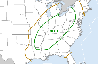
SPC severe storm risk for Tuesday
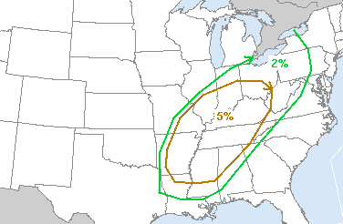
SPC tornado risk for Tuesday
This outlook, while looking ominous, is very conditional on that element of instability developing, which currently is looking questionable based on current model output. All of the models indicate no CAPE or negative LIs across the region today, as a band of precip and widespread clouds should be hovering over the area by midday. As the strong cold front kicks up a line of showers later in the afternoon, a wind threat will exist - but without instability, I can't see this bringing much of anything interesting, not even lightning for anywhere east of a Lexington-Cincinnati-Somerset line. All this would change anywhere that the sun can break out and start heating things up at the surface, so tomorrow's forecasting task will largely be centered on watching the visible satellite imagery for breaks in the clouds.
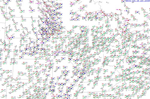
Speaking of the cold front - take a look at it crashing through the Midwest toward our region on the METAR mosaic, with strong northwest winds and subzero temps behind it! While the temps won't be as cold by the time it gets here, the winds should still be as strong:
As for me not chasing like I said I wasn't earlier - yeah right! Even with all of the negatives - and me knowing this will probably turn into a 300-mile heavy downpour fest - I can't ignore a 5% tornado threat in January. Who knows - this could be a 'sleeper' day that few expected. I'll be out somewhere as soon as things become clearer - hopefully having a target by noon or so.
|


