|
Home | Blog Index | Blog Archives | Christianity & Faith Essays | Storm Chasing Essays
Cristobal forecast to reach 65mph Sunday
Update - 11:58PM Saturday: In a change that would have almost made a Cape Hatteras trip worth considering, Cristobal's peak sustained wind forecast has been increased to 65mph - just 14mph shy of a Category 1 hurricane. If the storm continues to intensify as expected, I would not be surprised to see Cristobal reach hurricane status off of the Virginia coast on Monday. The center of the storm is still forecast to pass very close to the Outer Banks, possibly directly over them late Sunday. The catch-22 for storm chasers with this storm is that the farther the center is offshore, the stronger the intensity will be. If the center passes closer to or over land, the degree of strengthening may be reduced or eliminated.
Update - 11:12PM Friday: The NHC has declared this system Tropical Depression 3 as of their 11PM advisory on Friday evening. TD3 is expected to become Tropical Storm Cristobal within the next 24 hours and pass very close to, if not directly over, the outer banks of North Carolina on Sunday. The maximum sustained wind speed forecast for this system is only 40mph by late Sunday into Monday, making Cristobal a very minimal tropical storm as it affects the NC coast. As such, this will not be a chase event for me.
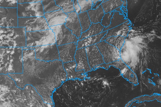
3:09PM Friday: The first tropical system to affect the US this season is developing off of the Georgia coast today. The circulation is very evident on satellite imagery, and the system could officially become tropical depression later today.
This will likely not be much of a chaseworthy event, bringing little more than some gusty winds and rain to the coastal areas from Georgia to Virginia. Cape Hatteras would be a fun place to be in the next few days, however.
I'd been watching the progress of this low pressure circulation when it was down near Florida, as earlier models indicated that it might drift inland more to the north, bringing storms and heavy rain to the southern WV mountains and coalfields this weekend. Now that the low track is actually heading over the ocean, not only does it introduce the possibility of tropical development, but the effects for West Virginia will be minimal aside from maybe a few high cirrus clouds.
|


