| Home | Blog Index | Blog Archives | Christianity & Faith Essays | Storm Chasing Essays
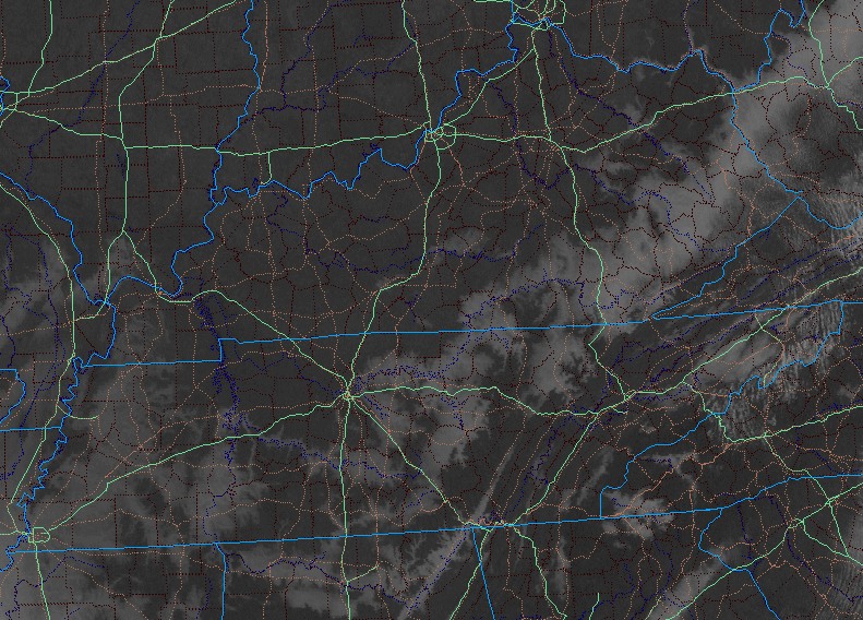
Valley fog on visible satellite
I found this in my daily check of satellite imagery. Most of the 'clouds' on this image are actually dense fog and valley fog on the western side of the mountains. You can clearly make out the fog following some of the larger river valleys (including the Ohio in the upper right hand side) and topography features in Kentucky, Tennessee and Alabama. The fog becomes more widespread and 'out of the valleys' farther to the east in West Virginia. The eastern boundary of the fog has been retreating most likely due to warming from the sun. The Mississippi Valley region is particularly fogged in around Memphis and surrounding areas. Looks like a nice clear day for a drive west on I-64 - I wish I could today!
click to enlarge
This was captured at around 10:35AM. If you read this post before 11AM or so, you can watch the animation of this.
need help w/ school project. told to find out what is the name and inventor of a large copper ball that either makes or attracts lightning. possibly has something to do with a solar panel??? make any sence?? 10 year old nephews project!! [email protected]
- Posted by Dillon | |
I think what you're describing may be a lightning rod - it doesn't attract or create lightning, though. There are some electostatic machines that can make sparks, some have a copper ball for each terminal (like a Wimshurst machine).
- Posted by Dan R. from Charleston, WV | |
Dan,
A pretty good trough in the plains is forecast for early next week. It's very early in the season.. but how do you personally try to handicap this far in advance whether or not there will be enough moisture, temp, and lift to make it a show.
- Posted by John from Texas | |
John, all you can really do this far out is try to nail down the large-scale upper air pattern - which in this case does favor severe weather. But the little details that determine whether we'll see a tornado outbreak or not are nearly impossible to forecast with certainty until a few days beforehand. Things like capping, strength of forcing and moisture depth all play a part in the delicate balance needed for tornadoes. Severe storms look fairly certain, but the jury is still out on tornadoes VS big squall line/wind event.
- Posted by Dan R. from Charleston, WV | |
Real good Dan. Thanks!
- Posted by John | |
|