|
Home | Blog Index | Blog Archives | Christianity & Faith Essays | Storm Chasing Essays
WV to see storms, flooding, snow - NC chase a no-go for now
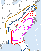 Update 3:12PM Monday: Sitting at my office computer now with the windows open, enjoying the 72F breeze coming in. I had planned on hiking in the New River Gorge today but work is keeping me inside (I have several web project tasks I need to finish if I'm going to be able to chase tomorrow). These temps in the 70s in early March mean something is brewing, so I'm still holding on to a slim chance of heading southeast tomorrow. A moderate risk will likely be in place across SC, NC and VA after tonight's SPC Day 1 outlook update (the image at left shows the current Day 2 outlook severe probs). Depending on how fast the squall line is moving east, a 'straight-line wind' chase may be worthwhile - that is, staying ahead of the storms on I-40 between Winston-Salem and Raleigh, stopping periodically to get multiple lightning/wind hits from it. I would have to turn around and head home afterward for the snow on Wednesday and/or Thursday night (which the models have actually backed off of slightly) - making this a $120 chase with current gas prices. That's a little high just for a squall line - but I may be able to eek out a video sale or two to at least cover the cost of fuel. If the squall line is screaming east at over 50mph, I'll pass on the chase as I'll likely only get one shot at it before it outruns me. Due to the timing of the event, I'll be able to hold off on a decision until tomorrow morning. If central and eastern WV can get a couple hours of sun tomorrow before the line arrives, a good lightning/wind event may be within my 'backyard home' chase area - negating the need to venture into 'extended home' territory. Update 3:12PM Monday: Sitting at my office computer now with the windows open, enjoying the 72F breeze coming in. I had planned on hiking in the New River Gorge today but work is keeping me inside (I have several web project tasks I need to finish if I'm going to be able to chase tomorrow). These temps in the 70s in early March mean something is brewing, so I'm still holding on to a slim chance of heading southeast tomorrow. A moderate risk will likely be in place across SC, NC and VA after tonight's SPC Day 1 outlook update (the image at left shows the current Day 2 outlook severe probs). Depending on how fast the squall line is moving east, a 'straight-line wind' chase may be worthwhile - that is, staying ahead of the storms on I-40 between Winston-Salem and Raleigh, stopping periodically to get multiple lightning/wind hits from it. I would have to turn around and head home afterward for the snow on Wednesday and/or Thursday night (which the models have actually backed off of slightly) - making this a $120 chase with current gas prices. That's a little high just for a squall line - but I may be able to eek out a video sale or two to at least cover the cost of fuel. If the squall line is screaming east at over 50mph, I'll pass on the chase as I'll likely only get one shot at it before it outruns me. Due to the timing of the event, I'll be able to hold off on a decision until tomorrow morning. If central and eastern WV can get a couple hours of sun tomorrow before the line arrives, a good lightning/wind event may be within my 'backyard home' chase area - negating the need to venture into 'extended home' territory.
Update 12:06PM Monday: The morning (12Z) model runs are out, and the WRF/NAM still keeps the main event west of Charleston until after dark Tuesday, and not arriving in Raleigh until the early morning hours of Wednesday. The GFS is slightly faster, bringing the squall line through Raleigh before midnight. Both models have the low pressure center passing directly over West Virginia, which even without good surface-based instability can be enough to produce thunderstorms and heavy rain.
QPF (total precip) with this system is quite high, with some flooding potential across West Virginia into Wednesday morning. This coupled with the nightly light snows starting Wednesday makes staying in Charleston this week seem like the more prudent choice.
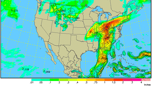
WRF/NAM precip forecast for 7PM Tuesday
Update 4:03AM Monday: The stubborn subfreezing snow prospects later this week refuse to give up, putting a damper on my intent to pursue the North Carolina setup tomorrow. There should be a fairly nasty squall line plowing through Raleigh late Tuesday night, with a high wind damage threat and a good tower lightning show likely. Although, it's interesting to note that the WRF/NAM keeps the system farther west, actully putting WV in the better position for storms Tuesday afternoon. If a good stratiform shield remains from Monday's storms and makes it this far, we may even get some decent lightning here in Charleston. Regardless, winter is almost over, so I'll probably opt to finish out my commitment to covering Oakwood/Fort Hill rather than give it a chance to pull another January 22. Once mid-April rolls around, I can finally close out that footage project permanently and be 'free to roam' for storm season.
5:04PM Sunday:
The system producing severe weather in Oklahoma and Texas today will strengthen as it moves into the southern US states Monday and Tuesday. Raleigh could be in the middle of the action on Tuesday, where intense upper-level winds will support a damaging wind threat and a conditional risk for tornadoes as a strong squall line moves through.
With several client meetings potentially scheduled for Friday in North Carolina, a chase would be convenient way to justify a weeklong trip to Raleigh starting tomorrow or Tuesday. The fly in the ointment is subfreezing temperatures and potential precip in Charleston on Wednesday, Thursday and Friday nights - scenarios that would necessitate staying here. Adding to the dilemma is the possibility of flooding in West Virginia Tuesday evening. So in a nutshell, the snow and flooding possibilities in WV need to be eliminated before I'll make a decision to head southeast tomorrow.
|


