| Home | Blog Index | Blog Archives | Christianity & Faith Essays | Storm Chasing Essays
Dry air, forecast update
Thanks to downsloping winds, some of the driest air I've ever seen in West Virginia was sitting over the region this afternoon - with dewpoint depressions (the difference between the temperature and dewpoint) topping 60 degrees in places. That is some dry air - a Napoleon Dynamite air mass, as in you'll be needing your ChapStick. Dewpoints are below zero in some areas! We normally don't see dewpoints that low unless we're in the middle of an arctic cold outbreak, with temps in the teens. With the forest floor still covered in fallen leaves, temperatures warming and most trees still bare, we're now in our spring wildfire season (the Appalachians have two - in the early spring and in the late fall). The dry conditions will only heighten the fire danger.
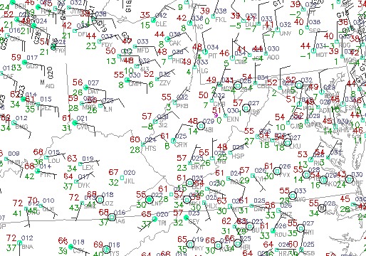
Obs at 7:41PM Monday
The interesting thing about this map is how you can see the downsloping effect that the easterly winds had. Dewpoints are in the 30s east of the mountains, then fall quickly as you crest the spine of the Appalachians. (Winds have shifted to the NE here when I captured this image).
So, back to the forecast. I'm a little encouraged by the 12z model runs today regarding the upcoming system for this weekend and beyond. The GFS has temps bottoming out only in the 40s on Monday morning:
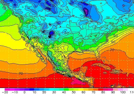
GFS temps for Monday morning
Then later that afternoon, warmer temps are already surging back north:
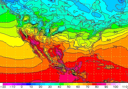
GFS temps for Monday afternoon
As long as that is kept up in successive model runs, I think we'll be OK from snow. Even the mountains aren't shown as below freezing on Monday morning. But, as I've mentioned before, weather forecasting means looking at more than just the surface conditions. And in this case, it's no different. The 850mb level (the layer typically just above the surface) is influential in snowfall events, and it's going to be cold up there on Monday morning:
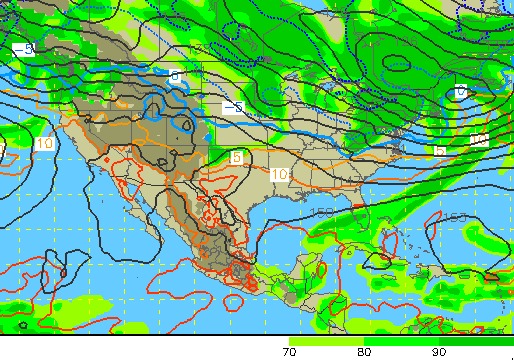
GFS 850mb temps/RH for Monday morning
The GFS says -5°C at 850mb (23°F) - so even with surface temps above freezing, snowflakes can still form aloft and fall to the ground if the showers are heavy enough. Heavy snow also has a cooling effect on the surface, just like dropping ice cubes into a glass of water. So, a heavy snow shower before sunrise Monday might be enough to cause some problems. Again, the GFS will probably warm things up as we get closer to this event, reducing or eliminating the snow threat - but we certainly can't turn our backs on this yet. By the way, the green shading on the map above is RH (relative humidity) - the higher values indicate close-to-saturation conditions at 850mb, which means thick clouds and usually precipitation. You can again see the upslope effect as the northwesterly winds hit the Appalachians, squeezing out the moisture (indicated by the higher RH values).
|


