| Home | Blog Index | Blog Archives | Christianity & Faith Essays | Storm Chasing Essays
Storm potential next week
The GFS and ECMWF models agree that we might have our next big upper trough to work with next week, around the April 1-4 time frame. I have some doubts about moisture due to the still-cold Gulf of Mexico waters, but as with most western troughs moving in, there should be at least a wide-area lightning event or two. Since we're still a week away from this, any details/placement of the system features are mostly guesswork - so I won't say too much other than that thunderstorms in the Plains, Midwest and later in the eastern US will be a good possibility. The wind fields will be supportive of severe weather if sufficient low-level moisture and instability can be realized.
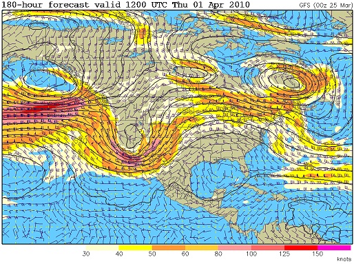
GFS 500mb winds for next Thursday
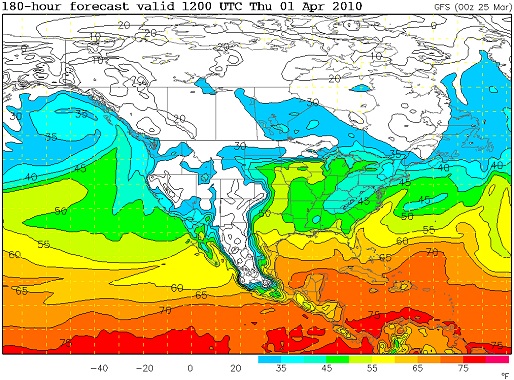
GFS dewpoints for next Thursday
The influence of this trough should be in the Plains/Midwest for a few days, so we will likely be looking at several potential setups through that time. I'll post more on these as we get to within a day or two of each event.
As for storm chasing, there is a potential problem with being closer to the Plains: it's more tempting to go after the lower-probability events early in the season. This runs the risk of chasing too much, too early, depleting funds for the heart of the season. This is especially true after an event already has produced a photogenic tornado out there in March, which can be a real 'chaser judgement' skewer. Being realistic, I don't think that the March 8 event is an indicator of the rest of the month (or the rest of the season).
So, while being on the eastern fringe of 'Tornado Alley' makes Plains events more accessable, I still have to be careful about a tendency to jump on everything. March is almost as likely to produce tornadoes in the Midwest as in the Plains this time of year. Taking all of that into consideration, I will be tending to pass on Plains setups until around mid-April, opting to instead enjoy some Day 2 setups' lightning when it moves through the St. Louis region. Of course, I'll evaluate each setup as it comes to see if an Oklahoma/Kansas trip is warranted - especially since I now have the luxury of waiting until the early morning on the day of the event to leave.
glad you had a good weekend, son. Hope to see you before long. Mom
- Posted by Mom | |
|


