| Home | Blog Index | Blog Archives | Christianity & Faith Essays | Storm Chasing Essays
Upcoming storm prospects - April 1 and beyond
The upper level wind pattern will shift to the storm chaser-loved western trough configuration by mid-week, leading to the severe weather-conducive southwest flow aloft over the Great Plains and Midwest. The only factor preventing this from being a surefire tornado event is the Gulf moisture depth/quality, at least by the time the system starts firing strong storms around the Thursday-Saturday timeframe. Nonetheless, this system's dynamics coupled with even marginal instability will almost certainly result in one or more severe weather outbreaks, with tornadoes possible. Models show that the first trough will exit over the weekend, while another takes shape over the west coast - possibly beginning to affect the Plains/Midwest with another round of potential severe weather/tornadoes next week.
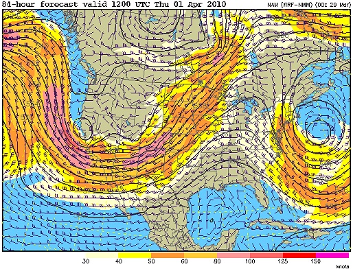
NAM 500mb winds for Thursday
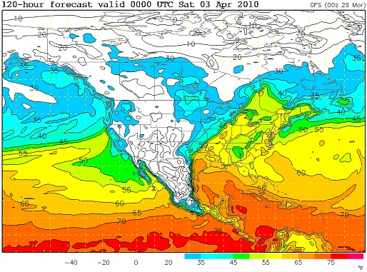
GFS dewpoints for Friday
As always, there's the standard disclaimer about this being 4-5 days out, and therefore details are just model-guided speculation. At this point, on Friday, the focus for severe weather looks to be in northern Texas as well as central/eastern Oklahoma. On Saturday, a potential setup may exist from St. Louis southward, including southern Illinois and western Kentucky (GFS showing strong mid/upper flow over 50F dewpoints, backed surface winds associated with a nearby surface low). Although the TX/OK event will likely be the better play for tornadoes, I'm leaning more toward hanging around the STL region for the potential severe weather event on Saturday (maybe even an overnight lightning show Friday night). I'll update on this more as we get closer.
While I'll make exceptions for a good enough setup, I'm not typically ready for hard-core multi-day Plains chasing in early April. Tax time crunches my travel funds; I'm usually in higher-intensity work mode to get my project board cleared for peak season; my vehicle is typically not yet fully prepared for long storm chase expeditions; and climatologically speaking, the bust-to-success ratio is higher this time of the year. Most importantly, I pay for all of my photography out-of-pocket, and so I have a finite spring travel budget - and therefore can't go after every setup the season offers. If I had unlimited finds, I wouldn't hesitate to jump on a Plains setup like Friday's. But late April and May is always the better time to bank on, even if the odd year or two is a bust (as in 2006 and 2009). I feel like it's better to risk missing some tornadoes early in the season in order to ensure the ability to chase more during the May-June time frame - which most years has been my more productive tornado time.
|


