|
Home | Blog Index | Blog Archives | Christianity & Faith Essays | Storm Chasing Essays
May arrives with complex setup in OK/KS
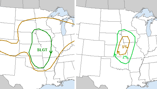
Today's SPC outlook - risk for severe (left), tornadoes (right)
So why am I not typing this post from my usual overnight stopover on I-44 in southwestern Missouri? I left Raleigh on Tuesday evening (16 hours earlier than planned) in order to get in position for a possible drive to southeast Kansas for today's event. I have been pessimistic about making a trip to the Plains all week, mainly because it looked like Thursday's setup was going to be the only one worth chasing. When I make a trip to the Plains from West Virginia, I like to have a multi-day chasing setup that gives me several good chances at tornadoes for my money spent getting there. A 'one-hit wonder' storm chase day can be nice, but if it busts, it's a very expensive and painful 1,000 mile drive back home.
Thursday's setup is benefitting from a great upper air pattern (the classic western trough moving in), but is suffering from a complex and shaky environment at and near the surface. A cold front earlier this week has pushed good moisture well south of the Gulf coast, and only recently have winds turned back southerly in advance of the approaching trough. Good, deep moisture has been slow to recover northward, as it has a great distance to travel to get to Kansas. A question still remains if the 60F+ dewpoints can make it into the threat area (eastern Oklahoma and Kansas) in time to benefit from the upper level wind support.
Even if the dewpoints can climb above 60F in Kansas in time, the question remains about a warm, dry layer just above the boundary layer. If winds at this level turn southwesterly, the dry layer can move overtop of the moisture at the surface and begin 'mixing' it out, reducing the boundary layer dewpoints and creating a strong 'cap' that inhibits convection. The situation is similar to the problems we had in nearly all of the 2006 May storm season, where moisture struggled to move north - and even when it did, it got obliterated by mixing from dry air aloft.
So in a nutshell, a single storm chase day - and a very conditional and questionable one at that - was too little to get me to commit to a trip this week.
There is a chance that moisture will recover today, and if that happens, the risk area may see a few tornadoes. The SPC's graphic above depicts the fact that they don't expect storms to fire in Oklahoma. If they do manage to fire, tornadoes would be a good bet. If moisture does win the battle, then I'd expect the SPC graphic to be modified to add a Moderate Risk with higher (and hatched) tornado probabilities, with that risk area extended south well into Oklahoma.
By Friday, the moisture situation is better at the surface - but winds at and near the surface look more 'unidirectional', that is, in the same direction as the upper level winds. This lack of 'directional shear' favors a squall line storm event over the Mississippi Valley (Missouri and Illinois in particular). By Saturday, the upper trough's energy is over Ohio, Kentucky and West Virginia - still more of a squall line setup, but one that might bring me a close-to-home storm chase day.
|


