|
Home | Blog Index | Blog Archives | Christianity & Faith Essays | Storm Chasing Essays
Forecast update #2 for May 13
Here we go on the roller coaster. Some interesting developments are starting to show up on the horizon of the ECMWF, another long-range model that we consult along with the GFS. The ECMWF is painting a very different scenario for the period starting around 10 days from now.
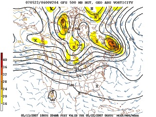
GFS 500mb forecast for May 22
It's a toss-up now. If this trough becomes reality and slows down enough to allow good moisture return from the Gulf, we may be in business for late next week. I'm a little concerned about how far north the trough is appearing at this point, but that will change as we get closer to the date.
For now, we need to go back on alert for a possible departure as early as next Sunday.
Based on the current outlook, this probability table charts the chance of our trip starting on a particular date:
| 2007 Storm Chasing Expedition - Departure Date Probability as of May 13 |
| May 12-18 | 1% | |
| May 19-25 | 32% | |
| May 26-June 2 | 32% | |
| June 3-15 | 32% | |
| No trip | 3% | |
|
GO: Home | Storm Chase Logs | Photography | Extreme Weather Library | Stock Footage | Blog
Featured Weather Library Article:
|


