|
Home | Blog Index | Blog Archives | Christianity & Faith Essays | Storm Chasing Essays
A tale of two models
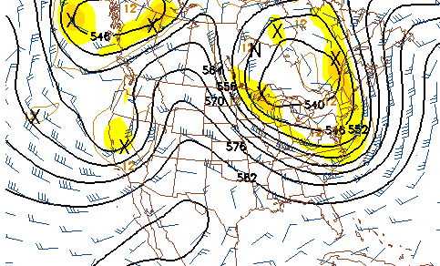
GFS 500mb forecast for May 25
 Two popular long-range forecast models I watch with regularity are the GFS and the ECMWF (the 'European' model), both with output to ten days (the GFS goes out to 14). As you've heard me say a million times, long range models are notoriously erratic the farther out you go, so much so that some meteorologists and storm chasers refuse to even look at them. However, if the same pattern forecast shows up over and over again each time the model is run, this consistency indicates a better probability that the forecast may actually have a chance of happening. Now - once a model is consistent over a period of days, then you compare its output to a 'competing' model. If they are in even slight agreement, then you've got an even more confident forecast (relatively speaking, as you'll rarely use the word 'confident' in any discussion of long-range forecasts). Two popular long-range forecast models I watch with regularity are the GFS and the ECMWF (the 'European' model), both with output to ten days (the GFS goes out to 14). As you've heard me say a million times, long range models are notoriously erratic the farther out you go, so much so that some meteorologists and storm chasers refuse to even look at them. However, if the same pattern forecast shows up over and over again each time the model is run, this consistency indicates a better probability that the forecast may actually have a chance of happening. Now - once a model is consistent over a period of days, then you compare its output to a 'competing' model. If they are in even slight agreement, then you've got an even more confident forecast (relatively speaking, as you'll rarely use the word 'confident' in any discussion of long-range forecasts).
The past few days, both the GFS and the ECMWF have been remarkably consistent in their forecasts. That's good, right? Well normally yes, but not this time - for late next week, they are (consistently) forecasting completely opposite patterns for the continental US - something I haven't seen in the time I've been chasing! The GFS wants to shut down the 2008 storm season, keeping a huge eastern trough and northwesterly flow over the Plains. The ECMWF, however, wants to bring a week of dream storm chase days, placing a huge western trough in a place that will ensure tornadoes happening daily somewhere in the central US.
When models are so consistent and yet so diametrically opposed to each other, there is little that a storm chaser can do but just wait. Eventually, one of the models will concede to the other's pattern. So which one win the battle this time? The European model is the favored one in situations like these, but such a strong signal on the GFS for the opposite to happen can't be ignored.
As for my chase plans - as you've seen, the DSLR won out this week over a trip. That will do it for my Plains chasing budget this spring, and therefore also my plans for a chase. The tour option is still open - and therefore I'll still leave that possibility reflected in the departure probabilities.
Based on the current outlook, this probability table charts the chance of our trip starting on a particular date:
| 2008 Storm Chasing Expedition - Departure Date Probability as of May 15 |
| May 9-25 | 2% | |
| May 26-June 15 | 8% | |
| No trip | 90% | |
|
|


