|
Home | Blog Index | Blog Archives | Christianity & Faith Essays | Storm Chasing Essays
Holding out for June
As the arrival of next week's system gets closer, the models' depiction of it generally can be trusted more and more. Right now, out of the whole system next week, Tuesday looks like it holds the best chance for tornadoes in a string of less-than-perfect setups. The trough kicks into the Plains, with strong winds aloft over top of 60s+F dewpoints. The hotspot on the GFS at this point appears to be central Kansas once again.
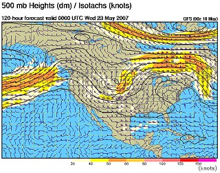
GFS 500mb forecast for May 22
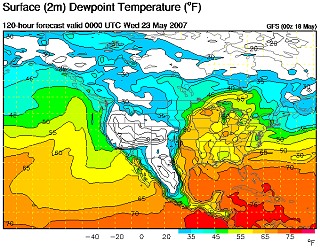
GFS surface dewpoint forecast for May 22
Tuesday is the only day that I see on the models that has any real promise. Other days, the moisture is either too meager or too far south of the strong upper-level winds. Interestingly enough, Thursday looks like it could produce some significant severe weather in Ohio, with the front end of the strong 500mb trough blasting over good moisture at the surface. I think we may be missing a marginal tornado day on Tuesday by doing this, but I still believe that waiting for something more significant and longer-lived in June is the better plan.
That said, the past few days of model runs have still not shown any consistent signals of a strong western trough. All we can do is wait.
Based on the current outlook, this probability table charts the chance of our trip starting on a particular date:
| 2007 Storm Chasing Expedition - Departure Date Probability as of May 18 |
| May 16-18 | 0% | |
| May 19-25 | 15% | |
| May 26-June 2 | 15% | |
| June 3-15 | 40% | |
| No trip | 30% | |
|
GO: Home | Storm Chase Logs | Photography | Extreme Weather Library | Stock Footage | Blog
Featured Weather Library Article:
|


