|
Home | Blog Index | Blog Archives | Christianity & Faith Essays | Storm Chasing Essays
Event trip on track, but with forecast issues
My departure date probability table has been flip-flopping around almost as much as the GFS model, taking into account a tough tax year, a high-mileage vehicle and uncooperative weather patterns. But even in this season that I'd already written off, the Lord continues to provide opportunities and turn things around.
The current plan is I will be teaming up with a chase tour group as an assistant/driver on a week-long chase starting on Wednesday. We are scheduled to depart from Amarillo, Texas on the 21st, and as long as the Lord wills and the pattern cooperates, will continue chasing through the middle of next week. I hope to be on the road westbound out of Charleston by mid-afternoon today, with a stopover somewhere west of St. Louis. The final 11 hours of the 19-hour drive will be completed on Tuesday, with an arrival in AMA by midnight.
The only caveat for this trip remains if the severe weather-favorable pattern completely vanishes, in which case the tour may be cancelled if the guests opt out. Unfortunately, Sunday night's model runs are certainly making me a little nervous. The problem with the upcoming system, at least according to model data, is that the main upper-level wind support of the huge western trough is going to be kept from moving east over the Plains. The culprit is the strong trough still sitting over us here in the eastern US, blocking the western trough from shifting east. The GFS forecast for Friday shows storms developing in the Plains, but with moisture too far east and the upper level support too far west:
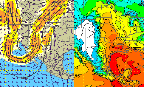
GFS 500mb & dewpoint forecast for Friday evening
Without strong upper level winds, storms will have trouble with precipitation falling back through or close to their updrafts, with does not favor overall storm organization. In other words, high-precipitation (HP) supercells that, if they manage to produce tornadoes, will not lend themselves to photogenic intercepts. This is all a rather big disappointment considering the outbreak scenarios depicted by the ECMWF model, which up until the past day or so had been showing a massive western trough and a huge eastern ridge. Now the European model has started to take on a blend of its old western trough forecast and the GFS' original eastern trough forecast, keeping both in the picture to form a classic Omega Block over the US (not good for storm chasing).
And that's just one of the major concerns with this system. In addition to the separation of the surface moisture from upper level support, an ironclad convection-inhibiting capping inversion on Wednesday and Thursday may keep storms from firing at all. And beyond Friday, the upper trough may actually start retrograding back west over the Pacific coast, leaving the Plains in a 'death ridge' of high pressure. According to tonight's GFS, Friday looks to be the only good chance of anything chase-worthy. Without that upper trough bringing strong flow aloft over the moisture, supercells and tornadoes will be tough to come by. Without the tour arrangement (which covers the majority of my costs), this is not looking like a system I'd choose to chase under normal circumstances.
However, somewhat encouraging is the 00z run of the NAM/WRF, which kicks the trough out a little more over the Plains - giving any storms more upper support. The cap is still problematic, but not as strong as the GFS indicates. So early this afternoon will be the 'go' or 'no go' time, as by then the mid-day model runs will be out. At this point, all indications are that the trip is still on track - in which case I'll be westbound as soon as I confirm the tour guests are also on their way.
As usual during a chase, I will attempt to update the blog with photos, HD video and chase logs as often as I safely can - so stay tuned!
Based on the current outlook, this probability table charts the chance of our trip starting on a particular date:
| 2008 Storm Chasing Expedition - Departure Date Probability as of May 19 |
| May 19-30 | 90% | |
| May 26-June 15 | 5% | |
| No trip | 5% | |
|
|


