| Home | Blog Index | Blog Archives | Christianity & Faith Essays | Storm Chasing Essays
Upper troughs and ridges
I thought I'd take a post to explain what 'troughs and ridges' are to my non-storm chasing blog readers, since those are terms I'm frequently using.
The atmosphere, as you've probably heard me say before, is made up of several distinct layers that vary in number and thickness at any given time. Each layer has its own properties such as wind speed, direction, temperature and humidity (dewpoint). We live in one layer here at the surface, but there are many more layers above us that influence the weather. Storm chasers pay a lot of attention to the weather patterns in the mid to upper layers of the atmosphere, as these usually play a significant role in influencing severe weather and tornadoes.
The main feature in the upper air layers is the jet stream. The jet is a corridor of faster winds aloft that tends to snake wildly around the globe, morphing and ever-changing from day to day. Jets are large-scale features whos configuration is critical to the type of weather we see down at the surface. The jet sometimes develops large-scale 'waves' that move across the USA. The areas where these 'waves' dip down are called 'troughs', while the areas that the waves peak are called 'ridges'. Troughs and ridges can either be very large, deep and amplified (longwave), or they can be subtle ripples in the flow called 'shortwaves'.
The front side of a trough is usually a hotspot for severe thunderstorms. The strong winds aloft create a 'sheared' environment, that is, change in wind speed and direction with height. Thunderstorms that develop in such a sheared environment are more likely to be severe and tornadic. The strong southwesterly winds aloft also promote a southerly flow at the surface, which helps pull Gulf of Mexico moisture northward into the middle section of the country. This 'river' of moisture develops a boundary with the dry desert air to the west called a 'dryline'. Low pressure circulations and frontal boundaries also tend to develop underneath strong upper jets, further enhancing the low-level shear environment that tornadoes thrive in.
Because of this, storm chasers like to see a strong upper trough with its axis over the western US states and its leading end overtop of the Great Plains. Here is an example of a good upper pattern for tornadoes in the Plains as depicted by the GFS model forecast for a few weeks ago:

Conversely, an upper 'ridge' over the Great Plains tends to cause winds at the surface to either slow or turn more northerly. This at best keeps good moisture from flowing northward, and at worst makes it flow back offshore into the Gulf. Ridges also feature too much warm air at the mid levels (a strong 'cap'), which reduces low-level buoyancy and makes it harder for convection to get started in the afternoon. Weak winds aloft (weak shear) cause any thunderstorm that can develop to collapse back in on itself (due to precip falling back through the updraft), limiting how organized a storm can get. A ridging pattern needs not be amplified to be detrimental to storms. All it takes is for the upper jet to move well to the north of the central USA to create 'ridge-like' conditions over the Plains and Midwest.
As a result, storm chasers dread seeing upper ridges in the Plains during storm season. A strong, long lasting upper ridge is called a 'death ridge' by storm chasers because it eliminates any real chance for tornadoes until the pattern changes. Every year, spring tornado season in the Plains comes to an end when the climatological summer 'ridge' establishes itself, usually by mid-June in the average year. A strong 'death ridge' that develops late in May can mean the end of the tornado season, as the 'death ridge' will quietly continue into the climatological summer ridging pattern.
Here is what an upper ridging pattern looks like on a model forecast:
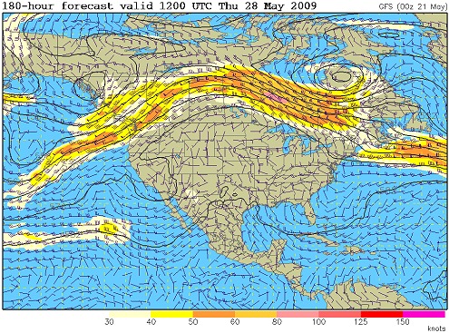
Unfortunately for storm chasers and the VORTEX II research project, that graphic above is the forecast for the upcoming week. The 2009 tornado season is currently 'ridged out', with little encouragement from forecast models that the pattern will change before summer. This is what the current upper pattern looks like:
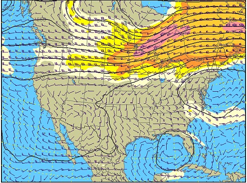
Notice the upper jet way up north, with no strong upper winds over the nation's midsection. While there is a subtle western troughing pattern there, the upper winds are so weak that it is of little consequence. The result will see a warming trend over much of the USA, with severe storms few and far between. Also notice the circulation in the Gulf of Mexico, keeping winds on the Texas/Louisiana coast northerly. That will keep Gulf moisture return from commencing anytime soon (and possibly result in a subtropical low development, even further detrimental to tornado season). As a storm chaser, I'm watching the models for a sign of a strong western trough to return, but so far none is in sight!
Thanks for that Dan,
- Posted by Mick from UK | |
|


