|
Home | Blog Index | Blog Archives | Christianity & Faith Essays | Storm Chasing Essays
Carolina-Appalachian storm chase expedition?
We're breathing a sigh of relief after seeing the meager and difficult storm chase days in the Plains on Tuesday and Wednesday. Initially, those two days looked like marginal tornado setups, so we chose not to travel to be there for them. Then suddenly, the setup gained much better potential after we'd already decided to sit them out. Like nervous game show contestants who passed on Door #1, we anxiously watched the events unfold, cringing at what we might have lost out on when 'Door #1' was opened. While there were a few tornadoes, they were either challenging intercepts, weak and/or short-lived. While I don't wish a bad storm chase day for other storm chasers who are out when we're not, it is certainly good to see our choice end up being the right one.
Nonetheless, when we start looking at what is ahead, there's not much reason to relish in our decision not to chase this week. Run after run, the models just aren't giving us any hope - not even the slightest glimmer of a western US trough. It's not over until it's over - but I'm quickly running out of optimism for the remainder of tornado season on the Plains.
Now for the silver lining. What the models do show is a large, strong trough developing mid-USA and moving east. The southwest flow looks very intense across the Southeast, Appalachians, Carolinas and mid-Atlantic during the first week of June, which could mean some severe weather outbreaks right here at home and close by in the surrounding regions.
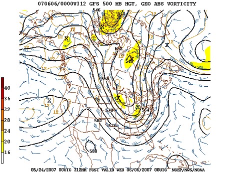
GFS 500mb forecast for June 6
Climatologically, tornado probabilities should be low with this type of setup, as we suffer from the lack of a dryline and a deep moisture 'conveyor' in this part of the country. The mountains also disrupt good southerly inflow. The other big negative I see is that the winds in the lower atmosphere are the same direction as the 500mb level, a configuration that lacks the 'directional shear' that supercells need to thrive in, and a big low pressure system may introduce widespread cloud cover. But give us a nice surface low, a warm front, and a portion of clearing sky, and we may have enough to produce a tornado event. Definately something to watch.
After the trough moves east, the GFS shows the belt of strong northwesterly mid-level flow diving southeast across the Great Lakes, down across Ohio, West Virginia and Pennsylvania, and finally sweeping across the Carolinas and mid-Atlantic. With typical late spring sunshine and surface moisture, this could set the stage for some northwest flow severe weather events. While the chances for tornadoes would be slim with those, some good lightning shows could be in store for us without having to drive more than a few hours away.
Will this system be enough to get us on the road for a multi-day chase in brand-new territory (as far as a planned storm chase expedition)? We'll have to see. If the models keep trending toward this possibility, we'll start planning for it more seriously.
Based on the current outlook, this probability table charts the chance of our trip starting on a particular date:
| 2007 Storm Chasing Expedition - Departure Date Probability as of May 24 |
| May 23-30 | 1% | |
| May 31-June 5 | 10% | |
| June 6-12 | 39% | |
| Non-Plains storm chase expedition | 25% | |
| No trip | 25% | |
|
GO: Home | Storm Chase Logs | Photography | Extreme Weather Library | Stock Footage | Blog
Featured Weather Library Article:
|


