|
Home | Blog Index | Blog Archives | Christianity & Faith Essays | Storm Chasing Essays
Trip #2 a go, for now

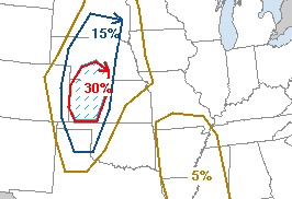
SPC outlook for Friday
Tonight's 00z model runs are now out, and both the GFS and NAM/WRF are still showing precipitation in central and northern Kansas on both Friday and Saturday evenings. SPC's new Day 2 outlook (above) reflects the favorable setup. Precip showing up in the forecasted high-instability, moderately-capped, high-shear environment means that supercells are likely. Since I have the luxury this time of waiting until the last possible minute (1:30PM EDT) for the SPC's afternoon Day 2 outlook and the morning's 12z model runs, I'll hold off on making an absolute decision about leaving until early afternoon. Nonetheless, at this point I'm about 90% sure I'm heading west after my meeting at work.
Western Kansas is a long haul from here, so I might go ahead and leave immediately after my meeting just to get a jump on the drive. I need to make at least Salina, Kansas, which is about 16 hours away. That gives me some time for rest without too much driving in the morning.
Based on the current outlook, this probability table charts the chance of our trip starting on a particular date:
| 2007 Storm Chasing Expedition - Departure Date Probability as of May 1 |
| Red - main expedition; Blue - May 4-10 trip |
| May 4-10 | 90% | |
| No May 4-10 trip | 10% | |
| May 11-20 | 33% | |
| May 21-31 | 33% | |
| June 1-15 | 33% | |
| No trip | 1% | |
|
| View 1,609 storm chases: |
| by year: |
|
| by type: |
|
|
|
GO: Home | Storm Chase Logs | Photography | Extreme Weather Library | Stock Footage | Blog
Featured Weather Library Article:
|