|
Home | Blog Index | Blog Archives | Christianity & Faith Essays | Storm Chasing Essays
Greensburg anniversary, 2-week forecast
 Exactly one year ago at this time (around 3PM CDT or so), I was driving eastbound on Highway 54 through the town of Greensburg, Kansas, on my way to a small area of surface convergence / cumulus that had popped up west of Wichita. I don't remember much about my short few minutes breezing through there, as with most of the hundred or so small Plains towns I've seen. Of course I had no idea of what was to happen about 5 hours later. I wish now I had least snapped a photo of something in the town (like the 'Big Well' water tower), as I normally do when I see an interesting landmark along the road. Exactly one year ago at this time (around 3PM CDT or so), I was driving eastbound on Highway 54 through the town of Greensburg, Kansas, on my way to a small area of surface convergence / cumulus that had popped up west of Wichita. I don't remember much about my short few minutes breezing through there, as with most of the hundred or so small Plains towns I've seen. Of course I had no idea of what was to happen about 5 hours later. I wish now I had least snapped a photo of something in the town (like the 'Big Well' water tower), as I normally do when I see an interesting landmark along the road.
So on to the outlook for the next 2 weeks. The GFS has flipped around on its mid-month Hudson Bay vortex forecast, and is now showing a large western trough moving into the Plains around a week from this Wednesday. That's as dramatic a change as you can get, which as you should know by now, is no surprise with a long-range model. The big trough has been there, in some form, for the past 4 consecutive runs now - lending some credibility to the forecast.
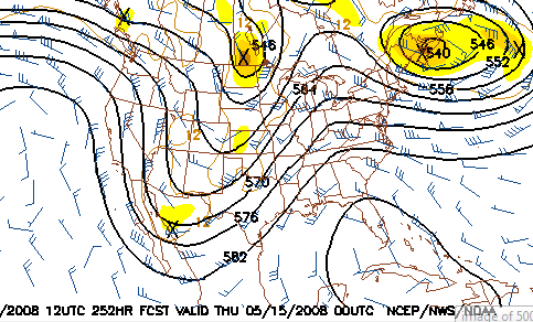
GFS 500mb forecast for May 15
With us now entering the heart of the Plains tornado season, such an upper-level pattern will likely have ample low-level cooperation with moisture, lift and winds near the surface - in other words, a pattern that means 'time to go chasing'.
Based on the current outlook, this probability table charts the chance of our trip starting on a particular date:
| 2008 Storm Chasing Expedition - Departure Date Probability as of May 4 |
| May 9-25 | 30% | |
| May 26-June 15 | 50% | |
| No trip | 20% | |
|
|


