|
Home | Blog Index | Blog Archives | Christianity & Faith Essays | Storm Chasing Essays
Icy road risk from Thursday through Friday
(This is an 'ongoing' post with new updates at the top)
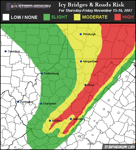
UPDATE 5 (9:37PM Thursday): Another non-event? It's looking like it. On radar, upstream activity in Ohio is waning, and the upslope banding over West Virginia is fading as well. Temperatures are also not dropping as fast as expected, even into SW PA where the models were indicating as much as 1 to 3 inches earlier. Based on this information, I'm heavily scaling back the risk area for the rest of the night. Still worth keeping an eye on, but icy road problems are looking less likely outside of the mountains. (Risk graphic updated below)
UPDATE 4 (8:29PM Thursday): The picture is becoming a little clearer now that the upslope snow event is unfolding. Two ribbons of moisture are being pulled southeast - one from Lake Erie into southwestern Pennsylvania, and one from Lake Michigan into central West Virginia. In many respects, most of West Virginia's upslope snow bands are 'remote' lake-effect bands. The moisture from the lakes gets carried to the mountains, where the 'uplift' of the higher terrain squeezes out the moisture in the form of snow. Aside from the current lake moisture plumes, I don't see any other evident sources of moisture for upslope snow to become widespread. So, I think the icy road risks will be confined to the narrow corridor where the banding sets up. Right now this appears to be taking place in central WV and SW PA, but could shift slightly north or south depending on if the winds carrying the lake plumes changes direction. Since the lake plumes seem to be the only sources for upslope snow moisture tonight, I think that the areas south of the current central WV bands will not see much, if any, icing problems. However, the current band is just north of Charleston, which means a slight shift to the south would put Kanawha County into the higher risk category late tonight. (Risk graphic updated below)
UPDATE 3 (6:02PM Thursday): A look at the radar and automated observations to our west into Ohio and Indiana show that not much is coming our way in the form of snowfall at this time. However, winds are forecast to become more favorable for heavier upslope-driven activity for most of West Virginia later tonight as temperatures fall. Whether or not this comes to pass as expected will determine the extent of the snow event across the state. Charleston changed over for a few fleeting minutes in the past hour, with flakes flying. But it didn't last - we're back to a rain/snow mix as we've seen most of the afternoon. For now I'll leave the risk graphic as-is.
UPDATE 2 (3:28PM Thursday): With Charleston's temperatures now at 39F and both the WRF and GFS models' QPF output indicating measurable snow just east of Charleston between midnight and daybreak, I felt that the eastern lowlands will see a slightly greater risk of icy bridges tonight. Charleston is already seeing a changeover beginning as of 3PM. Snow has been under way all afternoon in Beckley, and according to the Hampton Inn on Harper Road, the grass, trees and cars are already getting a coating. (Risk graphic updated below)
UPDATE 1 (11:53AM Thursday): Expanded the highest risk to include areas above 2000 feet, with upslope precip already developing this morning. Frozen precip has fallen in Charleston in the form of sleet, indicating the changeover in the mountains should be imminent. The lower elevations to the Ohio River should see some subfreezing precip overnight, but with only isolated areas within heavier upslope snow bands seeing bridge ice problems. (Risk graphic updated below)
ORIGINAL POST (11:03PM Wednesday): I put together this graphic showing the potential for iced-over bridges tomorrow night into Friday. The greatest risk areas will be in the mountains and northward into Pennsylvania, where one to three inches of snow are possible. From all indications, temperatures should fall into the mid and upper 20s just about everywhere west of the mountains, well past the threshold needed for any snow to stick to bridges. While the snowfall event itself will not be significant by any means, the travel hazard impact may be. Stay alert and take it slow tomorrow night and Friday morning!
Updated at 9:37PM Thursday
GO: Home | Storm Chase Logs | Photography | Extreme Weather Library | Stock Footage | Blog
Featured Weather Library Article:
|


