|
Home | Blog Index | Blog Archives | Christianity & Faith Essays | Storm Chasing Essays
Upslope Snow Case Study: March 17, 2007
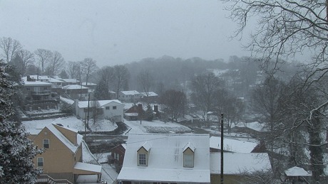
In a follow-up to the upslope snow primer I posted a few days ago, here is a classic case of an upslope snowfall event. On the early morning of Saturday, March 17, 2007, weak upslope activity that had been persisting all night suddenly intensified defore daybreak, turning light flurries into moderate snow that quickly coated bridges and overpasses. By mid-morning, over an inch of snow had fallen on Charleston, covering the landscape with a blanket of white.
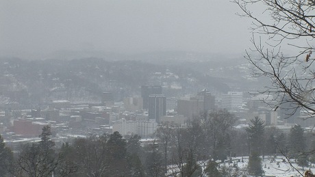
Accidents were widespread across the area, with more than 12 crashes and spinouts on the Oakwood Bridge.


The following image shows the surface observations from automated weather stations at the time of the March 17 snowfall. Note the winds coming across Lake Michigan, across Ohio and head-on into the Appalachian mountains (the 'wind barbs' on the map point in the direction the winds are moving). Also note the low pressure system in New England, indicating that a cold frontal passage had recently occured in West Virginia. The winds behind a cold front in the fall and winter are often oriented optimally for upslope snowfall. Notice the temperatures in the 20s across the state, well below freezing - allowing for bridges to cool rapidly enough for snow to accumulate.
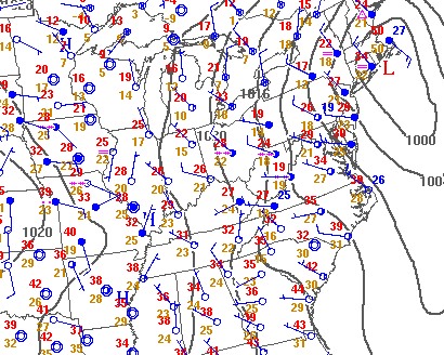
March 17, 2007 surface observations map
Using the NCDC (National Climatic Data Center) archives, I assembled this radar animation (from the RLX NWS radar site in Charleston) showing the intensification of the upslope precipitation over West Virginia on March 17 from approximately 4:30AM through 8:00AM. All of the car accidents due to icy bridges in the Charleston area happened during this time frame. Notice that the radar stays in 'clear air mode' through the entire event, as the radar echoes were not strong enough to trigger the automatic switchover to 'precipitation mode'. Also note the character of the upslope activity - not moving in from the west, but rather suddenly materializing overhead and 'training' between the Ohio River and the Virginia border. The wind trajectory that morning was favorable for lake-enhanced upslope snow, with a Lake Michigan moisture fetch hitting the western slopes of the Appalachians at a near-90 degree angle (as the surface map above indicates).

March 17, 2007 radar loop from RLX
Most of Charleston's upslope snowfall events come from these types of setups. While these upslope events are usually not major snowstorms (typically producing between 1/2 and 3 inches of accumulation), they are one of the biggest producers of icy bridge conditions in the area, and therefore are of significant concern for motorists.
GO: Home | Storm Chase Logs | Photography | Extreme Weather Library | Stock Footage | Blog
Featured Weather Library Article:
|


