|
Home | Blog Index | Blog Archives | Christianity & Faith Essays | Storm Chasing Essays
Icy road forecast for Tuesday-Wednesday
There is a slight risk of an icy bridge episode in West Virginia on Tuesday night, with the higher chances in the mountains. Snow looks like a widespread bet across the state by Wednesday morning. This post is an ongoing forecast, with new updates added to the top.
Update - 3:00PM Monday:
Here are the three factors I am watching for Tuesday night:
- Temperature: The new GFS model output on Monday morning still shows potential subfreezing temperatures across southern West Virginia on Tuesday night into Wednesday morning. The GFS shows a low temp range from 25F to 30F for Charleston and Huntington. The WRF has dropped its forecast several degrees for that time frame, showing a range of 30F to 35F. Looking at the actual chased temperatures of the air mass in the upper midwest which will be arriving in our area Tuesday night, the average seems to be the low 30s and mostly above freezing, suggesting that the lower elevations of WV will stay above the 32F mark.
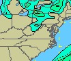 Precipitation: Both the GFS and WRF model do not show any QPF (total precipitation amount forecast) for anywhere but the northern and mountain sections of the state (image at right). However, snowfall amounts of less than an inch are usually negligible in terms of model QPF output, and as such the models will not paint a QPF shading for areas that may see a tiny accumulation of snow. Even the radars will stay in 'clear air mode' for these types of snowfalls because they 'look' weak in radar/QPF criteria compared to rain. For that reason, snowfalls of 1/4" to around 1" are hard to forecast using the models. Looking at the observations in the upper midwest, some isolated light snowfall is present around that region. This activity will be moving our direction and arriving on Tuesday night. Precipitation: Both the GFS and WRF model do not show any QPF (total precipitation amount forecast) for anywhere but the northern and mountain sections of the state (image at right). However, snowfall amounts of less than an inch are usually negligible in terms of model QPF output, and as such the models will not paint a QPF shading for areas that may see a tiny accumulation of snow. Even the radars will stay in 'clear air mode' for these types of snowfalls because they 'look' weak in radar/QPF criteria compared to rain. For that reason, snowfalls of 1/4" to around 1" are hard to forecast using the models. Looking at the observations in the upper midwest, some isolated light snowfall is present around that region. This activity will be moving our direction and arriving on Tuesday night.
- Upslope component: The big kicker for this event for us in West Virginia is the upslope component. The more perpendicular the lower-level winds are to the Appalachian mountains, the stronger the upslope 'lift' enhancement that will be present. Upslope can enhance weak existing snow bands or even create snow bands 'out of the blue'. Upslope snow bands don't usually move in from the west like a line of rain or storms often do - they form directly over the western slopes of the mountains from the Ohio river into the heart of West Virginia. This makes them hard to predict exactly when, where and if they will form. Indications for Tuesday night seem to show a strong upslope wind direction, which suggests to me the possibility of a good snow event across the region. However, with the small QPF amounts shown by the models, I'm remaning cautiously skeptical of anything more than a light dusting of snow in Charleston.
Will it be enough to cause bridge problems? Due to the borderline freezing temperatures forecast and the light snowfall amounts, I would put a 25% chance of an icy bridge episode in the Huntington-Parkersburg-Charleston area on Tuesday night. With temperatures well below freezing in the mountains along with models showing QPF shading there, I would say there is a 90% chance of icy bridges in the Beckley-Lewisburg-Summersville area during that time.
This is really a borderline event that is very hard to forecast either way. If the temperatures were just a few degrees higher, I could say with more confidence that roads will stay clear. We may not know until Tuesday evening, or even until the snow begins Tuesday night, what to expect.
First Update - 1:00AM Monday:
The new GFS model output on Sunday night shows potential subfreezing temperatures across southern West Virginia on Tuesday night into Wednesday morning. This scenario would create icy bridge hazards across the region if snowfall lingers through the night. The WRF model keeps temperatures above freezing through the entire event and confines a very light snowfall to the higher elevations (above 2500 feet). The lack of model agreement at this time means both scenarios are possible.
Original forecast - 1:30PM Sunday:
From the GFS and WRF model indications on Sunday morning, temperatures will be too high in Charleston for any slick road problems (bottoming out in the mid 30s). However, the Beckley area may dip below freezing before the snow tapers off, creating hazards at bridges and overpasses above 1500 feet or so. I am watching Charleston closely however, as if the air mass coming in from the northwest is colder than anticipated, the bridge ice risk will extend westward into the lower elevations as well.
GO: Home | Storm Chase Logs | Photography | Extreme Weather Library | Stock Footage | Blog
Featured Weather Library Article:
|


