| Home | Blog Index | Blog Archives | Christianity & Faith Essays | Storm Chasing Essays
Winter update: no snow for WV, icy roads chaos out west
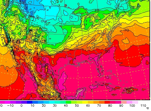
Quite a bit to talk about today on the winter weather/icy road front. First of all, as we draw closer to next week, it's becoming apparent that the GFS model completely busted the forecast on how far southeast the slug of cold air to our northwest would make it. The GFS is known for these things in the long range, so that's no surprise. All models now point to the cold air staying way up north and west, not even getting within 500 miles of us. In fact, it should be comfortably warm across the central Appalachians through midweek, with no readings below freezing even in the high country. Nonetheless, we're getting into mid-October, which is climatologically near the time when our region can start seeing its first snowfall. So, while we got a reprieve this time, it's not going to last for long.

NAM temps for next Tuesday evening
While the GFS busted the cold air/snow forecast for us here, it was mostly correct about what is happening out west and up north. Icy roads have, as expected, made their first widespread impacts from a swath stretching from Colorado to Minnesota. Hundreds of crashes were reported in most states, and the first US icy road death of the season occured in a Minnesota pileup. Nebraska saw one of its most significant early snowfalls in history, with over a foot reported in some areas.
All in all, it's made the first week of icy road season a busy one for maintaining the icyroadsafety.com site and feeds. Unfortunately that's only an indicator of things to come as we plunge deeper into winter weather season here in the USA.
|