| Home | Blog Index | Blog Archives | Christianity & Faith Essays | Storm Chasing Essays
Weekend storm forecast
It's been over a month now since my last chase outing, the only exception being a brief walk across the parking garage downtown on the 12th to shoot a few photos of a weak incoming storm. Again, not unusual for this time of year. October has traditionally been the better month for fall chases, and as we approach the end of September, a few events - albeit marginal - are showing up on the horizon.
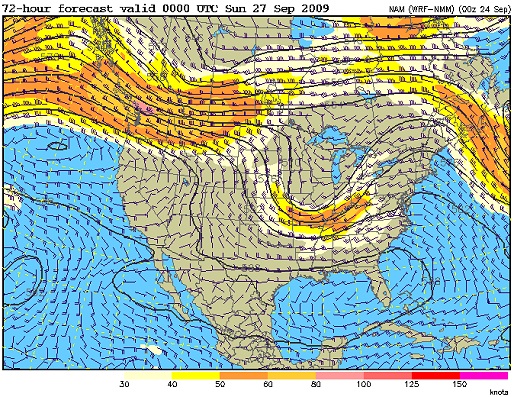
NAM 500mb winds for Saturday evening
I've been keeping an eye on this weekend, as a small upper-level trough starts swinging through on Saturday (as shown by the NAM model above). Plenty of heavy precip is shown with the approach of the resulting cold front:
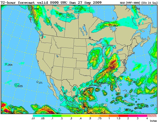
NAM precip for Saturday evening
Very little instability is shown for this system, aside from a sliver of weak CAPE in central Kentucky. This means that thunderstorms should be low-topped and therefore not great lightning producers. More than likely this will be a large mess of moderate rain by the end of the day that won't warrant any type of chase. What I will be watching for is a significant break in the clouds on Saturday morning, which will allow for greater destabilization and attendant severe weather risk. Again, even if we manage to scrape up some more CAPE, this isn't a "drive more than 30 miles" type of event - but a strong squall line might at least mean another round of tower lightning.
Beyond the weekend, models are hinting at more progressive (meaning moving rapidly across the country, as opposed to stagnating) troughing patterns. The GFS model has been pretty flaky lately, but shows a deep trough digging in over the eastern US on Monday followed by another setting up over the Plains. This type of dynamic upper flow pattern isn't that unusual for the transitional fall season, but the lack of instability tends to be the limiting factor for any real chase-worthy events associated with them. As always, they'll remain things to at least keep an eye on - as occasionally they can bring last-minute surprises.
|


