Storm Highway by Dan Robinson
Weather, photography and the open roadClick for an important message
Storm Highway by Dan RobinsonClick for an important message
Home | Blog Index | Blog Archives | Christianity & Faith Essays | Storm Chasing Essays

                   Friday, September 28, 2007 - 9:00AM

Tropical Storm Karen

By DAN ROBINSON
Editor/Photographer
Important Message 30 Years of Storm Chasing & Photography Dan's YouTube Video Channel Dan's Twitter feed Dan's RSS/XML feed

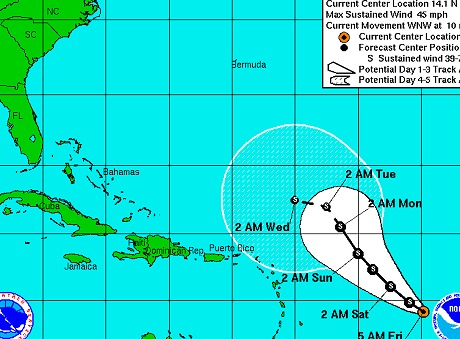
Tropical Storm Karen, an 'out to sea' storm for the past several days, has not been much to pay attention to up until today. The models are starting to suggest that Karen may begin to move closer to the US east coast by late next week. Karen is not expected to strengthen much in coming days. Any potential landfall location is too far away to predict, but is something to watch during the next week.

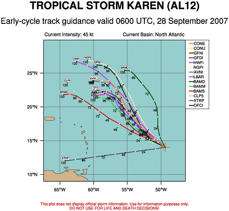
The image below shows the forecast tracks for Karen from several different computer models.

30 Years of Storm Chasing & Photography
Important Message
Dan's YouTube Video Channel
Dan's Twitter feed
Dan's RSS/XML feed

GO: Home | Storm Expeditions | Photography | Extreme Weather Library | Stock Footage | Blog

Featured Weather Library Article:

Lightning types
Anvil crawlers, bolts from the blue, sheet, ribbon and bead lightning. Learn how to identify each!
More Library Articles

All content © Dan Robinson. All usage requires a paid license - please contact Dan for inquiries.

Web Site Design and Internet Marketing by CIS Internet