| Home | Blog Index | Blog Archives | Christianity & Faith Essays | Storm Chasing Essays
Forecast update: storms fizzle, icy roads return
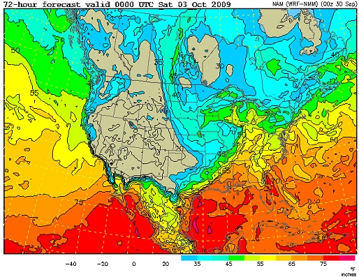
The NAM model tonight has backed off of any instability making it north of the southern Tennessee border for the duration of the upcoming upper trough passage. A narrow tounge of moisture (upper 50s dewpoints) is shown making it into our area ahead of the surface cold front, but this will likely be under an overcast sky - meaning the sun won't be able to heat up that juice to get any thunderstorms going to take advantage of the upper dynamics above.

NAM dewpoints for Friday evening
As always, fall season setups can pull some surprises - so I'm not turning off the lights on this one yet. The night before the tornado shown in the header image above - the Crosstown, Missouri F4 of September 22, 2006 - I was eating a late dinner at TGI Friday's with friends in Charleston, and decided to pull up some data on my laptop (Friday's has free wifi). My jaw dropped, and I was on the road westbound an hour later!
Icy roads a threat in MT, ID, UT and WY

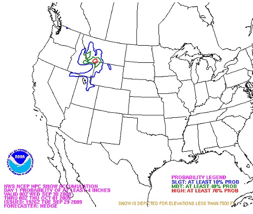
HPC snow outlook for the next 24 hours
The first major icy road event sequence of the season is about to begin in the intermountain West, Rockies and far western High Plains. While mainly a high-elevation event (above 5,000 feet ASL), many of the region's major thoroughfares and interstates will be affected. If you are traveling through these regions, be aware of the conditions - they will likely change rapidly from mile to mile!
With the return of icy road season comes the resumption of work on icyroadsafety.com. I'm hoping to do more with this in the coming weeks, so stay tuned.
|