Storm Highway by Dan Robinson
Storm chasing, photography and the open roadClick for an important message
Storm Highway by Dan RobinsonClick for an important message
Home | Blog Index | Blog Archives | Christianity & Faith Essays | Storm Chasing Essays

                   Tuesday, April 19, 2011 - 2:03PM CDT

Midwest storm chase day: April 19, 2011 (Update 2)

By DAN ROBINSON
Editor/Photographer
Important Message 30 Years of Storm Chasing & Photography Dan's YouTube Video Channel Dan's Twitter feed Dan's RSS/XML feed

From Dan: How the crime of copyright infringement took $1 million from me and shut down my operation.

In September of 2025, my work is generating the most income it ever has in my career. Yet, I'm being forced to shut down my successul operation, against my will, due to one cause alone: 95% of that revenue is being stolen by piracy and copyright infringement. I've lost more than $1 million to copyright infringement in the last 15 years, and it's finally brought an end to my professional storm chasing operation. Do not be misled by the lies of infringers, anti-copyright activists and organized piracy cartels. This page is a detailed, evidenced account of my battle I had to undertake to just barely stay in business, and eventually could not overcome. It's a problem faced by all of my colleagues and most other creators in the field.

If you would like to be notified when the chase video stream goes live, follow the Facebook or Twitter feeds.

Posted Tuesday at 2:00PM: An chase in an excessively convenient target is about to get under way. I will be activating my live streaming camera shortly - when that occurs, I'll post a quick notification blurb to the Facebook or Twitter feeds. Or, you can simply check back periodically at the Live streaming video page - if there is a little vehicle icon present, it means my video stream is active.

LIVE VIDEO PAGE: Live streaming video page

*            *            *            *

Posted Monday at 10:24AM: Spring storm season in the Midwest continues to ramp up with another wave of significant severe weather affecting the region. For today (Monday), a combination of instability, strong upper-level winds and directional wind shear will provide potential for severe storms mainly south of St. Louis around sunset. These storms should move across the metro area overnight, with a possible lightning show.

Tuesday brings the threat for a serious outbreak of tornadoes across the region. Strong instability, fast winds through the upper to low levels, a surface low in the vicinity and a warm front will provide focus for supercells. Directional shear is supportive of tornadoes.

NAM forecast sounding
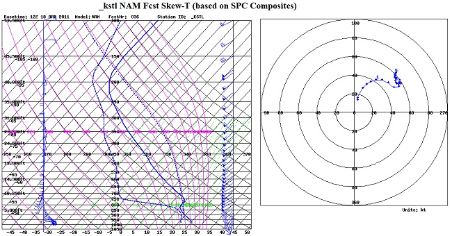
NAM forecast sounding for St. Louis Tuesday evening

These two days are 'backyard' events that I plan to be out chasing and streaming live video.

LIVE VIDEO: Live streaming video page

If you would like to be notified if and when the stream goes live, follow the Facebook or Twitter feeds.

30 Years of Storm Chasing & Photography
Important Message
Dan's YouTube Video Channel
Dan's Twitter feed
Dan's RSS/XML feed

GO: Home | Storm Chase Logs | Photography | Extreme Weather Library | Stock Footage | Blog

Featured Weather Library Article:

How lightning works
Does it go up or down? A detailed description of lightning from start to finish.
More Library Articles

All content © Dan Robinson. All usage requires a paid license - please contact Dan for inquiries.

Web Site Design and Internet Marketing by CIS Internet