In September of 2025, my work is generating the most income it ever has in my career. Yet, I'm being forced to shut down my successul operation, against my will, due to one cause alone: 95% of that revenue is being stolen by piracy and copyright infringement. I've lost more than $1 million to copyright infringement in the last 15 years, and it's finally brought an end to my professional storm chasing operation. Do not be misled by the lies of infringers, anti-copyright activists and organized piracy cartels. This page is a detailed, evidenced account of my battle I had to undertake to just barely stay in business, and eventually could not overcome. It's a problem faced by all of my colleagues and most other creators in the field.
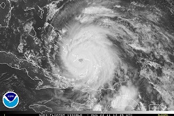
The following links are good for tracking the progress of Hurricane Irene via NHC data and satellite imagery, as well as fresh model forecast and intensity plots. The model plots are usually ahead of the official forecasts:
As much as I would love to, unfortunately I will not be able to chase Irene due to the $1,000-$1,500 total cost involved (that's if all went without a hitch) and the many days off of work that would be required. That's the reality of storm chasing these days!
Web Site Design and Internet Marketing by CIS Internet
From Dan: Please Read
To my regular readers, I offer my apologies for this heavy-handed notice. Unfortunately it has become necessary, so please bear with me!
Please don't copy/upload this site's content to social media or other web sites. Those copies have been a critical problem for me, seriously harming this site and my photography/storm chasing operation by diverting traffic, viewers, engagement and income. "Credit" and "exposure" does not benefit this site or my operation, rather they threaten my ability to cover my operating expenses. Please read my full explanation for this notice here.
Before continuing, check each box to agree to and acknowledge these two statements:
Click this button to finalize this acknowledgement:


 The following links are good for tracking the progress of Hurricane Irene via NHC data and satellite imagery, as well as fresh model forecast and intensity plots. The model plots are usually ahead of the official forecasts: