| Home | Blog Index | Blog Archives | Christianity & Faith Essays | Storm Chasing Essays
St. Louis winter storm forecast - what went wrong?
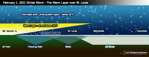
No crippling blizzard or ice storm for any of us here in the metro - so what went wrong with today's forecast? The killer was the warm layer aloft. Our atmosphere is like a layer cake, with layers of varying number and thicknesses from day to day. Snow needs uniformly subfreezing air in all of the layers, all the way to the surface, to make it to the ground and accumulate.
click to enlarge
Today over St. Louis, a few thousand feet up, there was a layer of warm air at a temperature of about 40°F, well above freezing. Above this layer, and below it down near the surface, the air was below freezing. In the storm, snowflakes developed higher above the warm layer, then fell through it, melting either partially or fully into raindrops. The liquid rain then entered the cold surface layer and refroze into hard pellets of solid ice, AKA, sleet. Where the warm layer was stronger, the warmer liquid rain made it all the way to the surface before freezing on contact with objects, AKA, freezing rain.
The warm layer is a snowflake killer: any location that had it overhead was getting either sleet or freezing rain. Sleet and snow are very different - snowflakes are light, fluffy and low-density crystals, while sleet is solid, dense ice pellets. As such, for the same amount of moisture, an inch of sleet would accumulate around 10 or more inches if it fell in the form of snow. Had the warm layer stayed south of us, we would be looking outside at easily a foot or more of snow, just as had been forecast. In essence, thanks to the difficult-to-forecast warm layer, we got the right amounts of precipitation, just not in the forms we expected. One only has to look just over 30 miles west of the city to see what would have happened if the warm layer aloft had not been a factor.
So go easy on the meteorologists with this one. Everyone made their forecast based on the best information we had. The science of winter weather forecasting, as with a lot of operational meteorology, still has a long way to go before we can start predicting these types of storms with greater certainty. That's no one's fault - we just haven't yet been able to develop our knowledge and tools to the level needed for that type of precision. Take the upper air layers for example (including the pesky warm layer in this storm) - the only way we measure those now are twice a day with 90 weather balloons that are fairly spaced out across the US. While we can extrapolate the data in between to some degree, better forecasts of this complex and dynamic atmosphere require much more detailed observations that we simply don't yet have. And that's just one factor.
With a storm such as this, it's better to heed what the data is indicating and 'dodge the bullet' later, than to ignore the signs in the skies and be unprepared for the eventual 'big one' that will happen.
|


