
 Dix, Illinois tornado and St. Louis supercell: May 25, 2011 Dix, Illinois tornado and St. Louis supercell: May 25, 2011
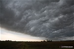
ABOVE: Rain-wrapped tornado west of Dix, Illinois
Click any thumbnail on this page to view a larger version.
DIX, IL - Strong midlevel and upper-level winds overspread a warm, moist air mass at the surface over the lower Midwest on Wednesday, May 25. A surface low in western Missouri advanced slowly east, adding vorticity and favorable low-level wind fields to the tornado ingredients. A rare "High Risk" was issued by the Storm Prediction Center with a high probability for tornadoes across the region.
The severe weather event actually got under way early in the morning, when a line of severe thunderstorms moved through the St. Louis metro. On my way to work at 6:45AM, I passed under a gust front shelf cloud with a dramatic "whale's mouth" on its underside near New Baden, IL:
I got off of work in eastern St. Clair County at 3PM, and did my first data check of the day. Supercells were already ongoing in southeast Missouri, but it would be over an hour before the St. Louis metro would see its first storm. A potent supercell eventually developed south of St. Louis and headed directly for the city. The intercept would be challenging due to rush hour traffic, but I decided to catch the storm over downtown. I was concerned about the storm turning right, as if it did, I would have been caught in the region of largest hail. Baseball to softball sized hail was reported with this storm in the western areas of downtown.
I parked on the Illinois side of the river downtown to chase the storm's approach. An apparent wall cloud was visible to the south, but there was no rotation visible:
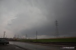
The storm looked organized on radar with a developing circulation passing directly overhead, but visually it was completely undercut with outflow. The low-level cloud features had no areas of rotation, and were all pushing steadily outward away from the storm. With ambient surface winds out of the south, the storm was not able to establish a good corridor of surface inflow needed to increase its tornado potential. Had surface winds been backed, I think this storm might have been able to produce a tornado here. Nonetheless, the appearance of the sky was dramatic for rush-hour commuters downtown.
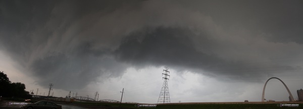
I quickly got onto the interstate and headed north on I-55/70 to keep up with the storm. Rush hour traffic thankfully was not too bad, and I had no problems maintaining a visual on the storm structure. It appeared that a wall cloud was beginning to develop and become well-defined, as if the surface inflow was finally able to reach the updraft:
However, when I got closer to the feature, again there was no rotation, and all cloud features and wind indicators (flags, trees) showed surface wind moving outward from the storm. With numerous other storms now ongoing to the south, I didn't feel that this STL metro storm would have much of a chance to tornado before its upstream inflow was cut off. So, I let it go and dropped back to I-64 eastbound to get into position for the next round of storms slated to cross between Mascoutah and New Baden.
I got caught in the northern section of the heavy precip of the New Baden storm as I approached and reached town, heading east on Route 161. Very strong southerly winds roared through town, and the power flickered and then went out. I finally saw clearing to the south about 2 miles east of town, but again, like with the STL storm, some ominous lowerings - but all outflow features.
At this stage, my options for interceptable storms were decreasing. Behind me to the west, storms had congealed into a squall line. About 40 miles to my south, a potent supercell with long-lived radar-indicated rotation was making its way north, but about to get swallowed by a mess of convection to its south and southeast. Finally, about 40 miles to my east, new storms were firing in clearer air near Mount Vernon. I liked the southern storm due to its persistence and easy intercept course, but feared it would quickly become absorbed into the convective mess before I could reach it. The eastern storms looked good due to no competing convection to the south, but they were not intensifying nor organizing well. With no other apparent options, I simply decided to just stay ahead of the squall line for the possibility of a new cell forming out ahead and to the south.
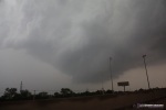
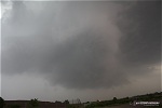
I reached Centralia when numerous rotation markers appeared on my radar display for a section of the squall line to the south. I have seen this happen with turbulent outflow in other major squall lines, so I did not expect to see much. However, I turned south out of Centralia to investigate. When I finally cleared the trees in town, I could see a long shelf cloud reaching from just due west to the southern horizon. A kink in the line was apparent about 10-15 miles south, with a very stout and vertically-shaped portion of shelf cloud on its leading edge. As it turned out, this was not a part of the shelf cloud, but a mesocyclone. Below this feature, a dense precip core with a sharp edge emerged from the haze. It did not appear tornadic at all, and I almost dismissed it and planned to just let the line overtake me here before heading home. I stopped at the US 51 interchange in Irvington to snap these two shots:
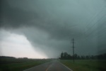
At this point I was staring at this feature thinking, "there is no way that's a wedge." But WxWorx now showed a shear marker of 126mph, then another. Then, the precip from the main squall line hit me - just as I decided to move east to keep whatever that was to the south in view. I headed due east on Dix-Irvington Road to keep up with the suspicious feature. The closer I got to it, it became apparent that it was indeed a tornado. I could not believe it after seeing how meager all of the isolated supercells had been, now the squall line kinks and tornadoes?!
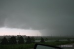
While I never got a good view of a well-defined edge of condensation on my approach, the rapid motion of the rain curtains/cloud tags indicated there was something big going on inside there. This is about 2 to 3 miles west of the town of Dix and I-57, looking due east:
  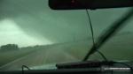
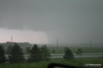
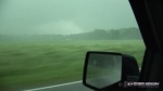
The tornado crossed the road about a mile or so east of me. I could not see this happen due to the rain overtaking me and eliminating visibility. Complicating matter is that I was entering into an area of trees. I finally reached a break in the trees and the rain to catch a glimpse of one side of the actual tornado just to the northeast:
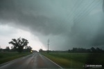
About 30 seconds later, I reached the tornado's crossing point. Power poles were snapped/toppled and a tree blocked the road:
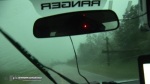
With the road blocked, my chase was over. There were no other quick detours around this spot. I backtracked about a mile to a winding, twisting, pothole-ridden road that eventually did get me to I-57, but the tornado was well out of reach by then. I encountered damage to homes and large trees on North Ridgeland Lane and later on Highway 37 and surrounding roads near Dix. Thankfully residents of the affected homes were OK.
With the squall line now well east of me, my chase was over. I dropped south to I-64 at Mount Vernon and was home by 9:30PM, and was treated to a spectacular sunset/rainbow/lightning combo on the way. Unfortunately I could not find a safe and suitable place to stop to catch any shots of this.
The tornado was surveyed and rated an EF1 by the Paducah NWS office. Details of the survey along with some damage photos can be found here:
Other nearby chaser reports from this day:
Did you get any more shots of the tornado?! I live in Mount Vernon, so not to far away!
- Posted by Melissa | | |
my husband is a spotter as well.. he saw the one that hit dix.. but he was heading home from work and didnt have a camera on him. thank goodness i went to centralia to see family that day.. i live in irvington just a few miles down the road from dix..
- Posted by tracey from irvington | | |
The photo above happens to be MY house/garage. What you DON'T see is that inside whats left of this garage are BOTH of our vehicles! You gotta love it!
- Posted by Tina from Dix, IL | | |
Tina, I'm very sorry to see what happened to your house and your neighbor's homes. It was good to hear everyone was OK. The parameters in place that day supported very strong tornadoes - thankfully this one wasn't as bad as it could have been.
- Posted by Dan R. from New Baden, IL | | |
Was there much or any damage done in the town of Dix? I live in Canada and have a friend living there.
- Posted by Rob from Canada | | |
|


