| Home | Blog Index | Blog Archives | Christianity & Faith Essays | Storm Chasing Essays
Another night-full of lightning around St. Louis - May 6 and 7
HD TIMELAPSE: Lightning and cumulonimbus at dusk, May 6
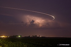
With a July-like weak upper flow regime entrenched, I wasn't willing to drive very far today. Strong instability was present virtually everywhere in the lower Midwest, and storms were likely going to be popping up somewhere close to home. With the exception of a slightly enhanced area of tornado potential *way* up north, the day did not look interesting enough to go on an expensive all-day chase. Sunday, I ended up driving to Jerseyville and back south through Alton to take a look at a couple of areas of convection that fired up after 4PM, but I didn't see anything of interest. Near sunset, a storm that fired south of Mount Vernon began to look interesting from my vantage point at home in New Baden. Rather than drive the 45 miles to it, I chose the 'distant cumulonimbus and lightning' option from just south of town. The timelapse above is a series of 5 to 20 second exposures (I lengthened the exposure time as darkness fell). Here are three of my favorite stills from the sequence (click for larger versions). In the first image, a plane (likely a military jet from Scott AFB) curves through the sky in front of the storm.
Click for larger versions
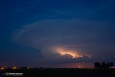
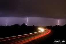
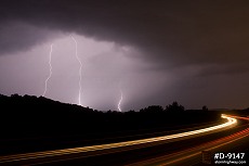
After midnight, storms to the west surprised me by maintaining their strength all the way across Missouri. While not even remotely severe, they kept up sufficiently in the lightning department. I headed to the west end of the St. Louis metro area along I-44 near Eureka to grab a few shots. The middle image below is a 3-frame stack:
Click for larger versions
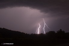
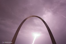
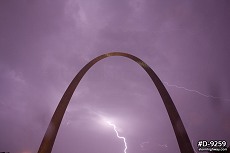
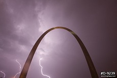
I rushed back into downtown for the possibility of new development taking place over the city. While that didn't happen, the complex of storms eventually (slowly) propagated over downtown St. Louis. Initially the show was mainly anvil crawlers, but transitioned to all positive cloud-to-ground (bright, branchless and loud). Fighting a continuous battle against lens raindrops, I set up a low angle shot hoping for an anvil crawler explosion over the Arch. While I didn't get that, a few of the positive CGs made it in frame. I was set at F8 for anvil crawlers initially, which made the first +GC overexpose. I adjusted to F11 for the rest.
Click for larger versions
|


