Storm Highway by Dan Robinson
Storm chasing, photography and the open roadClick for an important message
Storm Highway by Dan RobinsonClick for an important message
Home | Blog Index | Blog Archives | Christianity & Faith Essays | Storm Chasing Essays

                   Thursday, April 17, 2014 - 11:29AM CST

Storm chasing forecast update for April 18 - 30

By DAN ROBINSON
Editor/Photographer
Important Message 30 Years of Storm Chasing & Photography Dan's YouTube Video Channel Dan's Twitter feed Dan's RSS/XML feed

From Dan: How the crime of copyright infringement took $1 million from me and shut down my operation.

In September of 2025, my work is generating the most income it ever has in my career. Yet, I'm being forced to shut down my successul operation, against my will, due to one cause alone: 95% of that revenue is being stolen by piracy and copyright infringement. I've lost more than $1 million to copyright infringement in the last 15 years, and it's finally brought an end to my professional storm chasing operation. Do not be misled by the lies of infringers, anti-copyright activists and organized piracy cartels. This page is a detailed, evidenced account of my battle I had to undertake to just barely stay in business, and eventually could not overcome. It's a problem faced by all of my colleagues and most other creators in the field.

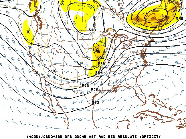
We finally have something on the horizon to watch! Both the GFS and the Euro model agree on at least two upper troughs swinging through the center of the USA beginning late next week. As it's shown, the first potential storm chase day afforded by the first wave would be in the Wednesday-Friday time frame, followed by a several-day down period before the second wave arrives (pictured below as depicted by the GFS model).

Right now these systems are shown to have the classic synoptic-scale ingredients we need for tornadoes (upper support, instability, dryline, directional shear, breakable cap), but in reality we will not have any real confidence until we get within 3 or 4 days. The models are simply not that trustworthy this far in advance. To complicate matters, both the Euro and GFS want to keep the troughs a little too far to the north for my liking, which could lead to moisture issues - particularly for the first wave. Regardless, I like what's being shown enough to bump up the probabilities for the first 2014 Great Plains trip happening either late next week or next weekend.

Stay tuned - more updates will follow as new model data is available over the coming days.

The following table charts the probability of a Great Plains storm chase expedition happening for several indicated date ranges in the near future:

2014 Plains Storm Expeditions - Probabilities as of April 17
April 18-220%
April 23-2740%
April 28-May 340%

30 Years of Storm Chasing & Photography
Important Message
Dan's YouTube Video Channel
Dan's Twitter feed
Dan's RSS/XML feed

GO: Home | Storm Chase Logs | Photography | Extreme Weather Library | Stock Footage | Blog

Featured Weather Library Article:

Lightning myths
Take a look at these common lightning myths. You might be surprised!
More Library Articles

All content © Dan Robinson. All usage requires a paid license - please contact Dan for inquiries.

Web Site Design and Internet Marketing by CIS Internet