| Home | Blog Index | Blog Archives | Christianity & Faith Essays | Storm Chasing Essays
St. Louis severe weather/tornado day photos and video - April 3
HD VIDEO 1: Morning tornado sirens and University City damage
HD VIDEO 2: Evening tornado sirens and lightning downtown
Wow - there's going to be a lot to recap in this post! This was, by far, my longest single storm chase/coverage event ever (not counting hurricanes), eclipsing even all of my past winter storms - and I never left the St. Louis metro area! I left home at 11PM on Wednesday night to head downtown, expecting an approaching warm front to begin firing thunderstorms near the city as several models had indicated. I did not end my coverage of the storms until 24 hours later, when the last of the lightning moved away to the east. This is the first observe where I stopped at home to eat dinner and take a quick 1-hour nap in the middle of active severe storms. That might be the first instance I know if in an actual chase that made the dinner-during-a-tornado-outbreak scene in the movie "Twister" seem legitimate!
I spent the first part of this event in downtown St. Louis from 11PM Wednesday to around 4AM Thursday, expecting thunderstorms to rapidly erupt on a warm front moving in from the south, as models had indicated. This ended up happening on either side of the metro area (east and west), with a lack of action on the front over the metro area. This wasn't a big loss, as thick fog and low clouds on the cool side of the front scraped the tops of the buildings and the Arch. That would have made any lightning photography impossible, even if a storm had moved over at that point. With the warm front activity a bust, I headed west to Chesterfield to chase the squall line moving in from the west.
The squall line seemed at first like it was going to be a dud, with lightning activity dropping off to nearly nothing as it approached the Missouri River. However, instead of a gust front from the apparently weakening line, rain curtains suddenly appeared in the city lights out ahead of the line, racing south to north into a base just barely visible in the still-infrequent lightning. As I moved east on I-64, a wall cloud was visible to the north as I approached I-270. There was very little lightning after that point to chase features, so I continued on to downtown. Strong southerly winds with low clouds and narrow precip bands racing north preceded the squall line. Normally you'd expect westerly winds with a gust front leading a line like this, especially just before dawn. Tornado sirens sounded in the city, and I began to see power flashes to the north. Reports of damage in University City started coming in, so I headed there to chase (see the video clip or the gallery on the Facebook page for these images).
After spending about an hour at that scene, I stopped to attempt to capture some upward lightning at a tower off of Hanley as additional storms moved over. The upward lightning was a no-show, so I headed back to Chesterfield to chase the next round of storms moving in from the west. At Chesterfield, I could see a very dramatic laminar arcus cloud on the leading edge of the outflow. I continued on to the Weldon Spring exit for a higher vantage point of this scene. While not severe, this arcus formation was quite impressive:
The storm approaches the St. Louis National Weather Service NEXRAD (LSX) radar dome:
I headed back downtown to shoot this storm moving over the city, but it weakened considerably with lackluster lightning activity. It was now noon, and at this stage I had to make a decision. My original plan for this event was to shoot the early rounds of thunderstorms in the St. Louis metro area, then head west on I-70 to position for the afternoon/evening 'main event' of supercells and tornadoes along the warm front in central Missouri. However, by now it was obvious that plan was not going to work out as expected. Numerous storms had gone up in southern and central Missouri, spreading a dense anvil canopy over my original target area from Sedalia to Columbia. In addition, the morning thunderstorm activity along I-70 into St. Louis had shoved the effective warm front much farther south, and it was not showing signs of surging back north. New thunderstorms were constantly going up nearly everywhere in Missouri, indicating that there was not much of a capping inversion to hold off storm development and/or keep things isolated.
It appeared that the only real play left was on the warm front in extreme western/central Missouri, where the sun was out and heating things up and where storms had yet to initiate. This was a very narrow corridor however, and would require roughly a 4-hour drive to position myself there. That prospect wasn't very attractive to me, but I started the drive west anyway. On the way, I stopped in Chesterfield (for the third time this day) to make a data stop and evaluate the situation again. I was really wanting to talk myself out of making that long drive, because something just wasn't right about it. And sure enough, radar showed numerous storms beginning to fire in western Missouri and along the Kansas/Missouri border. The "too many storms - not enough capping" problem appeared to also exist out there as well, which was all I needed to convince myself to stay on my "home turf".
Right as I made my decision to not head west, a tornado watch was issued for southern Illinois, beginning one county south of my apartment. I wasn't liking the radar trends over there (it consisted of the weak storm I'd just chased over downtown), but there was a small area of sunlight making it through. With most of the atmosphere over the St. Louis metro heavily worked over after multiple rounds of storms, I didn't see any other reason to not just go home and regroup. If anything, there was a tornado watch just to the south of home to play with. By now I was approaching 21 hours without sleep (awake since 5PM Wednesday) and really needed a break. I got home, ate a quick dinner and took a one-hour nap that worked wonders to temporarily recharge for the final round of this event. By 6PM, I was back out the door and headed west to intercept the next batch of storms heading for the metro area.
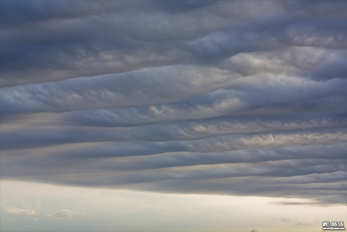
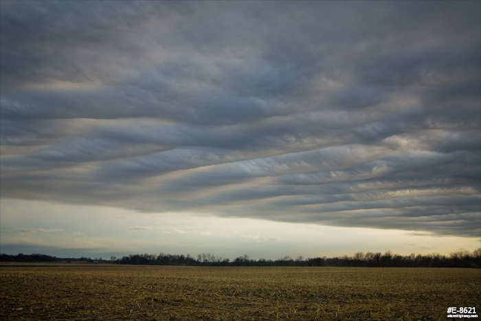
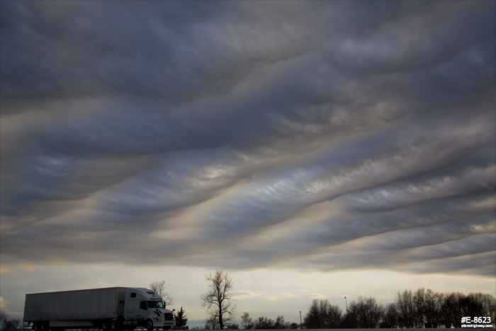
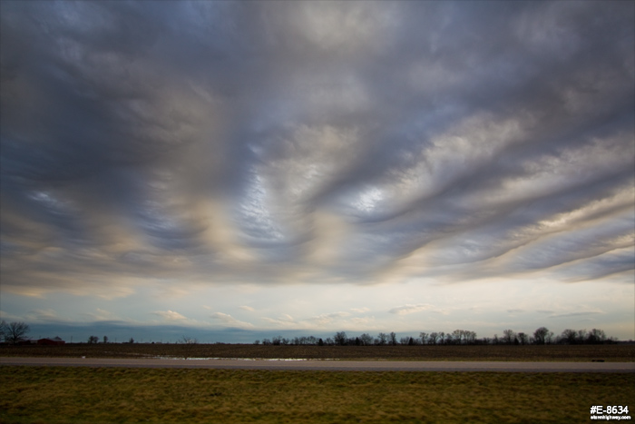
As I left New Baden, I was surprised to see some spectacular "undulatus" clouds drifting by. These were worth making a couple of stops to shoot some photos, and actually were one of the highlights of this day!
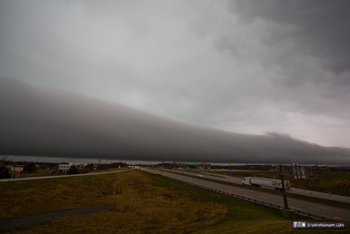
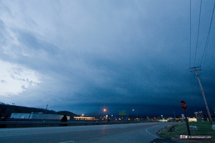
I made my way through downtown again and down I-44 to catch the next potent storm moving in, which became tornado warned as I passed Valley Park heading west. I stopped in Allenton (next to Six Flags) to monitor the storm's approach, intending to keep ahead of it on the interstate. A very dramatic shelf cloud appeared in the distance with frequent lightning:
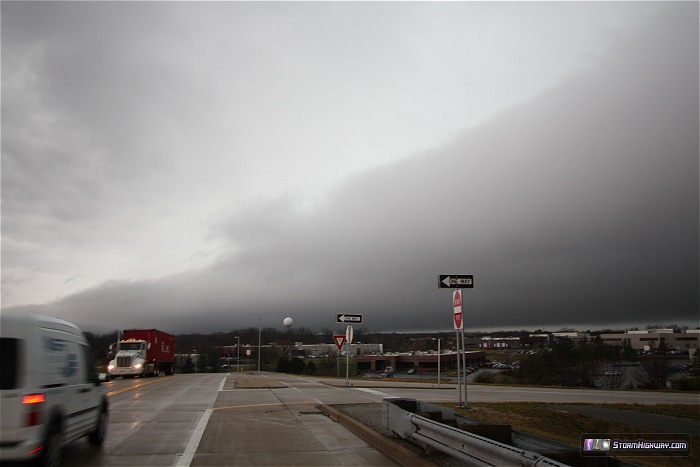
At this point, there was not any radar-indicated circulation of note in the storm, and the shelf cloud signalled strong outflow dominance. However, a well-defined v-notch developed in the line to my northwest as the strongest portion began bowing out. A 'kink' like this can often precede a QLCS-type tornado, which I thought might be visible in the lightning if one were to form. I headed up to Wildwood to better position to view this feature, which would have passed just to my north. Precip began filling in this notch rapidly, and I never saw any signs of development either visually or on radar. I continued on up to Chesterfield (for the fourth time that day) and took I-64 east to get downtown in advance of the storm, now tornado warned. I arrived just in time, setting up to get these shots as tornado sirens wailed all over the city:
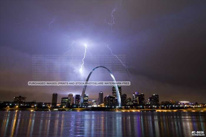
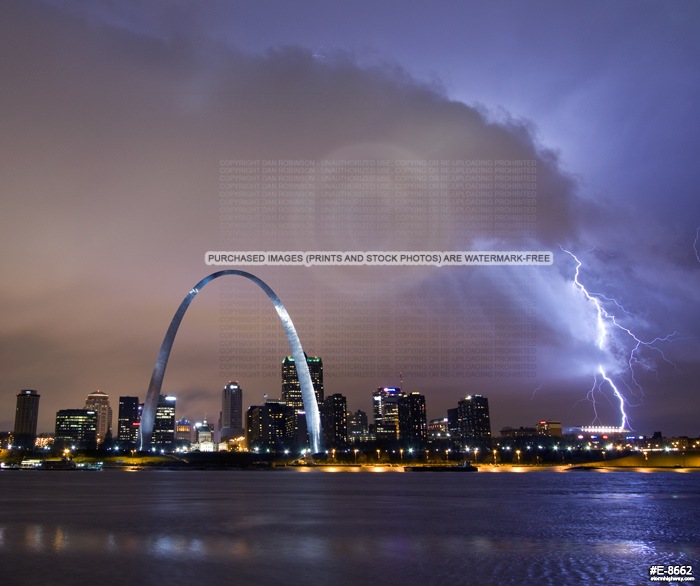
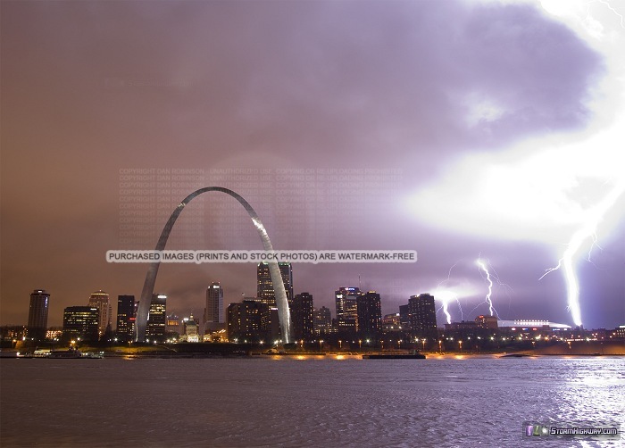
I was admittedly nervous as this was occuring. I was away from my car and without radar, with only the wind and visual signs to let me know if a tornado could be approaching. As the cameras rolled, I was intensely watching the cloud motion and wind direction indicated by flags over downtown as well as at my location. I was also watching for power flashes, which would be a near certainty if a tornado was moving over the core of the city. Thankfully, all clouds and wind were westerly everywhere that I could see, which indicated solid outflow over the downtown area. And no power flashes. Any tornado threat should have been either south or north of downtown, but I kept a close eye for any sudden wind shifts and power flashes. Thankfully, there was no sign of a tornado threat over downtown while I was set up. Had there been one, I had already scouted out several shelter options if the worst case scenario unfolded.
I scrambled back to the car as the heaviest precip arrived, and headed east on I-64 toward home, intending to get some final views of the storms before I let them go after getting back to my apartment. In East St. Louis, I was finally beginning to get ahead of the storm - when strong northerly winds and heavy rain suddenly began sweeping across I-64, just before the Kingshighway exit. This can be a sign of a developing or in-progress tornado to the south! And sure enough, a couplet showed up on radar at this time, just to the south of me crossing I-255, moving east-northeast. I slowed down at Kingshighway as the wind rapidly shifted out of the south. A couple of dim power flashes flickered both to the north and to the south of the road. The radar-indicated couplet was still ahead of me and south of the interstate, so I wasn't sure exactly what to think. Visually, it appeared that the circulation should have been north of the highway. Due to the conflicting visual and radar clues, I kept a close eye on both the north and south sides of the road for any signs of danger.
I was out of the precip by the time I reached the Caseyville exit, and had a good visual on the cloud base just ahead. Short-duration power flashes popped every 15 seconds or so to my northeast, north of I-64. I was not certain that this was a tornado or simply outflow, especially since the radar had shown the now-fading couplet to be farther south. So, I hesitated to call it in. A tornado should have been producing more frequent power flashes given the populated area, and I could not make out any visual signs of rotation or a funnel. I passed an overturned car and RV trailer just past the Fairview Heights exit. I could not determine whether this was caused by the storm, particularly due to a long traffic jam behind the accident that suggested it had happened too long ago to be associated with this current storm.
I arrived at home well ahead of the storm, now passing off to the north of town. A final batch of storms were approaching from the west. The strongest of these was well to the south, with an impressive VIL spike on radar which suggested large hail. The lightning activity was not very impressive, so I chose to not pursue it. I monitored the approach of this last line of storms, and seeing nothing of note on radar or visually, finally let them go east of town. I ended the storm chase day at that point, 22 and 1/2 hours after I'd started. I lost count on how many rounds of storms I had seen all day, probably between 8 or 10 (maybe more). It was an interesting an enjoyable day, but I was glad to finally be able to get some rest.
Fantastic pictures! Enjoyed your post immensely!
- Posted by George Duffield | | |
Nice pictures Dan! And thanks for the detailed account too. Really puts the reader "there". One question please. What do you use to display real-time radar data in your vehicle? A standard laptop with 15" screen? Or perhaps a large-screen cell phone with 4G? Thanks.
- Posted by John M from BC Canada | | |
Nice pictures! Yeah, the tornado outbreak never really materialized because of a lack of cap over Missouri so the storms just kept firing and therefore, kept instability down. It maybe cleared up for less than 20 minutes.
- Posted by Tim | | |
|


