| Home | Blog Index | Blog Archives | Christianity & Faith Essays | Storm Chasing Essays
Storm chasing forecast update for April 1 - 10
There are a couple of storm forecast items to talk about as we move into April. The first 'chaseable' upper trough is swinging through the US this week, bringing what looks like two workable storm chase days on the dryline in Oklahoma and north Texas on Tuesday and Wednesday. These two days are followed by what seems to be the 'main event' of the system on Thursday, right now shown from eastern Oklahoma and Kansas through Missouri and Arkansas. The SPC Outlooks cover these in detail, and I'm sure most storm chasers have already seen them, so I won't rehash those.
The Tuesday and Wednesday events are no-brainer days for Oklahoma and northern Texas storm chasers, but I'm not so sure I'm 'feeling it' enough to make the long drive for the first Plains trip of the year. This is mostly because I have a busy work week in store that is necessary to keep the chase fund healthy. There will be some potential here in the Midwest to cover with this system, which tends to influence me to stay here anyway. I'm not completely sold on the idea of staying home, so I'm not reducing the Plains trip probabilities to zero just yet. The advantage to living out here is that I can make a final decision as late as early Tuesday morning, and still make it in time.
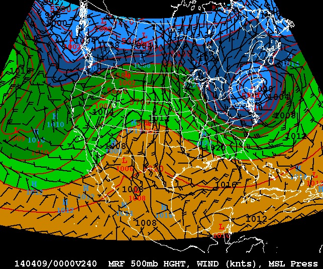
After this week's upper system moves east, long range models agree on a deep eastern trough taking root by the 9th (shown above). This would mean a good lull in severe weather potential in the Midwest and Plains until at least the 12th or so. The good news is that right now the models seem to want to keep the pattern progressive, instead of locking that big trough in for a week or more. In that case, the next chaseable system could be here around the 15th - but that's really way too far in the future to make any sort of call. Right now, it looks like if I don't jump on this week's system, the first Plains trip won't be a possibility until the middle of the month. But of course, that can always change.
The following table charts the probability of a Great Plains storm chase expedition happening for several indicated date ranges in the near future:
| 2014 Plains Storm Expeditions - Probabilities as of March 31 |
| April 1-4 | 5% | |
| April 5-10 | 10% | |
| April 10-15 | 20% | |
|
Wednesday doesn't look like a good day to chase considering the capping inversion and the fact that it's mostly a hail threat over a small area (according to the SPC). No moderate risk areas yet.
- Posted by Tim | | |
My bad. There's a tornado threat wednesday but there's only a small window. After sunset it'll be mostly a hail threat. Oklahoma City's included in the 15% hatched area that day.
- Posted by Tim | | |
Yes - definitely worth chasing if you live near there, but not worth a big trip from up here.
- Posted by Dan R. from New Baden, IL | | |
Thursday's the 40th anniversary of the super outbreak. Obviously Thursday's forecast outbreak isn't going to be anything like the super outbreak but there could be a moderate risk issued by tomorrow. There hasn't been a good april outbreak since the day 2 high risk a couple of years back.
- Posted by Tim | | |
|


